
When it comes to hiking in Peru, there is truly something for everyone. We have identified the 27 best treks in Peru for you to explore, noting the trek overview, the experience, the difficulty level and the highlights of each. Whether you want an easy hike in the tropics or you’re ready to embark on a week-long alpine adventure, you will find your perfect Peru hike right here. The list includes hikes as long as 12 days to as short as 1 hour. You’ll find well-known hikes like the Inca Trail and Salkantay Trek, and lesser-known ones like Marcahuasi and Laguna Churup. By the end, you’ll realize why Peru is considered a hiker’s paradise.
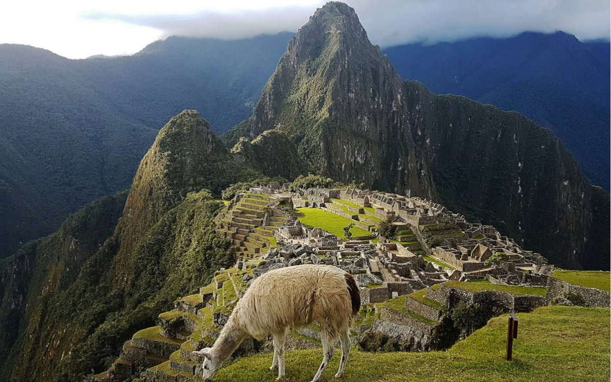
Choquequirao is a Quechua word that translates to “cradle of gold” and is considered the sister city of Machu Picchu. The trek allows you to see both of these awe-inspiring citadels hidden in the majestic Andes on one unforgettable adventure. Aside from exploring the well-preserved Inca ruins that were once metropolises for nobles and priestesses, you’ll see some of the most beautiful vistas, flora and fauna that the Andes has to offer.
The launching point for this trek is the historic city of Cusco. From there you will be transported to the village of Cachora, which is the starting point of the trek. The trail traverses mountain passes, glacial lakes, fertile river valleys, high jungle and canyons, taking you to Choquequirao on day 3 and Machu Picchu on the last day.
Choquequirao Trek to Machu Picchu is considered moderate, as much of it is at a fairly low elevation. However, there are a couple strenuous days mixed in as you go pretty steadily uphill for two days straight. There is also a mountain pass that reaches over 15,000 feet. That being said, anyone with a good level of fitness and hiking experience should be able to do this trek.
Hike with us! Check out our Choquequirao to Machu Picchu daily itinerary.
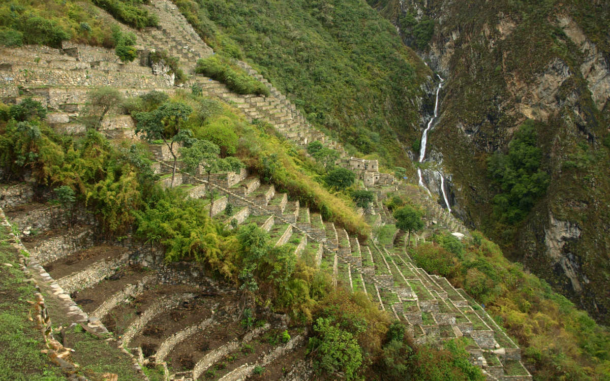
Machu Picchu’s sister site “Choquequirao” with beautiful cascade in the distance. Image by Matthew Barker of Peru for Less.
For nature lovers, the Salkantay Trek may very well be the ultimate way to get to Machu Picchu. At 20,574 feet above sea level, Salkantay Mountain is the highest in the Vilcabamba Mountain Range and 12th highest in Peru. Salkantay actually translates from Quechua to savage or invincible, and you’ll see why the first moment you catch a glimpse of this piercing snow-capped peak. The trek showcases some of the most beautiful landscapes of the Andes, transitioning from rolling valleys to alpine passes to high jungle. The trek itself can be done in either 4 or 5 days. There is also a Salkantay Lodge-to-Lodge trek where it’s the same hike but you spend each night in the comfort of a warm bed.
The hike begins in the village of Soraypampa then crosses through Andean valleys before reaching Salkantay Pass on day two. From there it descends along rivers and lush greenery through the high jungle and ends in the town of Aguas Calientes, from which point you head over to the Machu Picchu citadel.
Besides day two, this trek is considered moderate. Day two is a challenging day where a steep switchback takes you to 15,000 feet above sea level for a breathtaking view of Salkantay Mountain. Overall, anyone with hiking experience and good level of physical fitness should be able to do this trek. However, those who are worried about the high altitude ascent on day two may want to consider hiring a horse for that day.
Check out what you’ll do each day on the 5-day Salkantay Trek.
Apu Ausangate or Ausangate Mountain is considered by the people of the Andes to be a holy mountain. It is also the fourth highest mountain in Peru at 20,945 ft (6,384 m) and the highest in the Vilcanota Mountain Range. While for tourists a hike to Ausangate is an unforgettable adventure, for the local people it is considered a sacred pilgrimage. Whether you are looking to traverse some of the most beautiful scenery in the world, or wanting to tap into that sanctity on a reflective journey, this is the experience for you.
The trek launches from the city of Cusco and the trailhead is in the village of Tinki. On this hike you’ll traverse around grasslands, valleys, lakes and mountain passes; and circle near Ausangate about halfway through. The trek actually ends in the town of Tinki as well, where you will celebrate the end of your voyage with a traditional Pachamanca lunch.
For three of the six days the gradient is considered strenuous and challenging, not only for the distance and steepness but the elevation as well. The highest mountain pass is almost 17,000 feet above sea level with two other days well above 15,000. The other half of the trek is considered moderate. Trekkers should have a good level of physical fitness and some experience hiking at high elevations.
Click here to learn more about hiking the sacred Ausangate Trek.
Ausangate Mountain is considered sacred. Image: “Sunset on the Cordillera Vilcanota snow-capped mountains” by sergejf on Flickr under the CC BY 2.0 License / cropped, compressed and resized from original.
This lesser known trek beholds everything you’d wish for on an Andean adventure: Inca ruins, snow-capped mountains, green river valleys, high jungle and even semi-tropical rainforests — without the crowds. Vilcabamba translates from Quechua to “sacred plain” and is commonly known today as Espiritu Pampa, which translates from Spanish to “plain of the spirit.” On the Vilcabamba/Espiritu Pampa Trek, you’ll traverse some of the most beautiful parts of the Vilcabamba mountain range, making your way to the Vilcambamba or Espiritu Pampa ruins embedded in the lush jungle nearby the Chontabamba River.
This trek launches from the city Cusco, where you’ll take a transfer to the village of Huancacalle to start toward your first archaeological sites of Rosapata and Vitcos. After coursing through mountain passes, valleys and rainforests you make your way to Espiritu Pampa on the final days and depart from the village of Kiteni along the Urubamba. Prefer to see the Vilcabamba Range and Machu Picchu? No Problem! The 5 day Vilcabamba to Machu Picchu trek will give you the best of both worlds.
This trek is rated moderate, with the 2nd day being the hardest as you reach the 12,664 foot (3,860 m) mountain pass. From there it’s downhill through the high jungle and rainforest with 4 to 7-hour days of hiking. Anyone with a fair level of physical fitness and love for nature and hiking can do this trek.
Check out the daily breakdown of our fascinating Vilcabamba/Espiritu Pampa Trek.
Trekking Tours:
The Inca Trail follows the footpaths of ancient Inca nobles through mountain and cloud forest to the historic sanctuary of Machu Picchu. The classic trail takes 4 days and is considered one of the top 10 in the world. Hikers from all over the globe flock to this popular trek, which must be booked at least 6 months in advance during high season as permits sell out quickly. This trail is a protected archaeological site, with precious ruins and beautiful Andean scenery throughout.
The Inca Trail launches from Cusco and the trailhead is in the village of Piscacucho. From there, you’ll course past river valleys, alpine tundra, lush cloud forests, archaeological sites, and ancient tunnels and stairways. Finally on day 4 you’ll enter Machu Picchu through the Inti Punku, or Sun Gate, to start your exploration of the famed ruins. The variety of natural landscapes and ancient ruins make this one of the best treks in Peru.
The Inca Trail is rated moderate to strenuous. The strenuous part is mostly due to the steep ascent and switchbacks on day two. The highest point, Dead Woman’s Pass, takes you to 13,828 feet above sea level so it’s a good idea to acclimate 2-3 days before your trek begins. Anyone with a good level of physical fitness and some experience hiking should be able to do this trek.
See the daily breakdown of the classic Inca Trail to Machu Picchu and be sure to reserve your spot in advance.
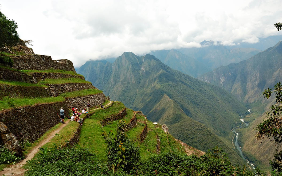
Ancient Inca ruins along the Inca Trail in Peru. Image by Peru for Less.
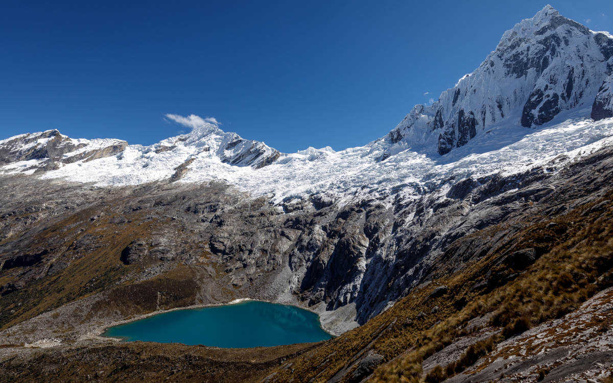
This is an incredible hike that gives you panoramic views of Peru’s famous Cordillera Blanca. The centerpiece of this trek is the striking Alpamayo Mountain. This 19,500 foot (6,000 m) peak covered in snow spikes steeply into the sky. An otherworldly vision for hikers, it is considered by some mountaineers to be the most beautiful mountain in the world. The name Alpamayo translated from Quechua to “earth river.” You’ll see this and so much more on your 10 day journey through the Andes.
The launching point for this trek is the city of Huaraz. Then, a car ride takes you to Vaqueria where your trek begins. The trail courses past glacial lakes, high passes, and green valleys and ends at the village of Hualcayan.
Alpamayo Base Camp hike is rated strenuous. Though it dips under 10,000 feet in elevation on the last day, this trek is well above 13,000 feet from start to finish. Trekkers should have experience hiking at high altitude before embarking on this trek.
Located in the Andes Mountains of Peru you’ll find the Huayhuash Circuit, one of the most revered mountain circuits in the world. The compact Cordillera Huayhuash, or Huayhuash Range, is characterized by high altitude passes, vibrant turquoise lakes, Andean flora and fauna and soaring snow-capped peaks. There are even some hot springs along the way to soothe your muscles and warm your bones after a long day of hiking.
The launching point for this trek is the town of Huaraz. From there, you’ll be taken to the village of Llamac, which is both the start and end point of the circuit. The classic circuit as done with a tour typically takes 12 days, though some operators and independent hikers can complete it in 8–10.
Huayhuash Circuit is rated strenuous and is recommended for serious trekkers only, who are accustomed to cold weather and high elevations. With many of the passes above 16,400 feet (5000 m), this rugged trek attracts seasoned alpine hikers from around the globe.
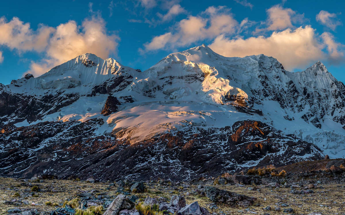
Along the Huayhuash Circuit you’ll see Yerupaja Mountain, the 2nd highest mountain in Peru. Image: “The south face of Yerupaja” by Jeremyfrimer, used under the CC BY-SA 3.0 License / cropped, resized and compressed from original.
If you’re a hiker heading over to the Arequipa area of Peru, you definitely want to explore Cotahuasi. Cotahuasi Canyon is twice as deep as the Grand Canyon, with waterfalls, petroglyphs and Andean wildlife hidden like treasures within it. The trek itself is not a point-to-point trek but rather a series of day treks that often start and end at the same campsite or village. Each day you can explore a different highlight of the canyon, usually first by being transported to the trailhead and then embarking on the hikes, which are about 3-5 hours or so. Keep in mind exact hikes may vary depending on what tour operator you choose.
The treks within Cotahuasi launch from Cotahuasi Village, which is located about 6 hours by car from Arequipa. From there you are transferred to your trek of the day, whether it be an archaeological site, a waterfall, hot spring, ruin or viewpoint. This remote, off-the-beaten-path hiking destination is full of amazing surprises. Plus, seeing the deepest canyon in the Americas is a huge travel accomplishment. A visit to Cotahuasi can be extended to around 7 days if desired, which just means exploring more of its hidden wonders.
The trek difficulty for Cotahuasi is considered easy to moderate, with longer hikes having a couple strenuous points. The length of the treks are not too long, about 3-5 hours and you have plenty of time to rest before and after them. Some uphill parts can make you a bit winded since they can reach over 12,000 feet, but anyone with a bit of hiking experience should be fine. It’s a good idea to acclimate for a day or 2 before embarking on the treks.
The Lares Trek is a popular trek option to Machu Picchu, especially for lovers of culture. This 4 day hike takes you through the mountains, valleys and villages that lead you to the famous citadel. It’s an excellent option for adventurers who would also like more insight into traditional Andean cultures and how locals have adapted to the modern day — all while preserving and honoring their ancient heritage. You’ll have a chance to see residents’ textiles and ceramics, and even directly support them by purchasing a one-of-a-kind handmade item.
The hike launches from Cusco then takes off from the trailhead in the charming Lares Village. The trek begins by weaving through the Lares Valley, coursing high mountain passes, traditional weaving towns and picturesque lakes. It then reaches the town of Ollantaytambo, known for its ancient Inca fortress, then continues onto Aguas Calientes. After a night relaxing at an Aguas Calientes hotel, you can get rested and ready for the grand finale: your tour of Machu Picchu.
Lares Trek is moderate overall, but there is one quite challenging ascent to a 14,600 foot pass (4,450 m). You will hike 4-7 hours per day. Anyone with some hiking experience who has acclimated in Cusco 2-3 days before the trek should be fine.
Embark on a cultural adventure – see the Lares Trek itinerary.

Taking a rest along the Lares Trek to Machu Picchu. Image: Matthew Barker Peru for Less.
Huchuy Qosqo is an ancient pre-Inca settlement. The name, also spelled Yuchuy Cuzco, translates from Quechua to “little Cusco.” A hike to these ruins is a unique adventure that takes you through valleys, mountains and lakes characteristic to the Cusco region. The ruins, which you’ll explore on day 2, sit at 11,980 feet (2,920 m), on a green terraced hill. You’ll feel how special this place is when you go over the Inca bridge and follow a stone walkway to get there. This hike is the perfect little addition to your trip to the Andes, and a wonderful way to experience the Sacred Valley.
The Huchuy Qosqo Trek launches from Cusco and the trailhead begins at the ruins of Tambomachay just outside the city. From there you will hike Tambomachay Valley, various high mountain passes, admire the Ccauca ravine and make a stop at the Qeullacocha Lagoon before the campsite in the community of Pacamarca. The next day you’ll make your way to the ruins and then finish your trek in the village of Lamay.
Huchuy Qosqo is rated as moderate to strenuous, due to the many mountain passes that you’ll be climbing (three in one day). Other than those passes, which stay below 14,000 feet in elevation, the trek is moderate, taking you through comfortable gradients across the valley. Day one you’ll hike around 6 hours and day two 5 hours.
Learn about the inclusions and daily breakdown of the Huchuy Qosqo Hike.
The 2-day Inca Trail is an express version of the classic 4 day Inca Trail to Machu Picchu. The Inca Trail is one of the most famous treks in the world, and this option allows you to experience a little piece of that magic in a shorter period of time. This trek is perfect for anyone who wants the experience of arriving at Machu Picchu by foot through the iconic Sun Gate, but does not want to commit to or perhaps does not have the time for 4 days of hiking and 3 nights of camping. You still get to experience some of the very best sites of the Inca Trail on this expedited journey.
This hike launches from Cusco and then you take a train to the trailhead at km 104. From here, you’ll wind through various ruins and ancient green pathways before reaching the Sun Gate. Once you walk through the Sun Gate you’ll get your first glimpse of Machu Picchu then spend the night in your Aguas Calientes hotel before touring the entire citadel the following day.
The 2-day Inca trek is rated as moderate due to uphill sections and some uneven ground. It does not reach the high elevation passes of the classic 4 day Inca Trail, but it does have some areas that will take a good effort. In reality, it is one full day of hiking, not two. The second day is dedicated to touring the Machu Picchu citadel. The whole hike on day one takes 6 or 7 hours and anyone with some hiking experience should be able to do this trek. As with any trek in the Andes, it’s a good idea to acclimate in Cusco for two or three days before your trek.
Reserve your spot on the short 2-day Inca Trail to Machu Picchu.
See Machu Picchu (and its 4-legged residents) on day 2 of this popular hike. Image by mlproject on Piaxabay.
The Gran Vilaya Trek is a lesser known journey in the northern Amazonas Region of Peru that takes off from the town of Chachapoyas. The trail takes you through the subtropical highlands that are right at the edge of the Amazon Rainforest. Enjoy the beautiful scenery while learning about the ancient Chachapoyas culture. You’ll even make a stop at multiple archaeological sites, including the Kuelap ruins, which is an impressive walled settlement that was built in the 6th century.
Chachapoyas is the launching city for the Gran Vilaya trek. From there you’ll be transported to the trailhead in the town of Cruz Pata. Then you’ll course past various ruins, gorgeous river valleys, cloud forests, mountain passes, villages and dense vegetation with the Kuelap ruins as your grand finale. It is a super unique Peru trekking experience, with amazing plants and wildlife throughout.
This trek is easy to moderate. The ascent to Yumal Pass at 11,000 feet is the most difficult part of the trek. The trail ranges between 5,500 and 11,000 feet above sea level so elevation should not be a hurdle, and two of the days are only 2.5 hours of hiking. The other days are 6 and 8 hours so those will be a bit more of a push in terms of endurance. In general, besides Yumal, there is nothing too challenging in the way of gradient or elevation. Anyone with some hiking experience can do this trek.
Santa Cruz Trek is arguably the most popular trek in the Cordillera Blanca (White Mountains) of Peru. For 4 days, this trek traverses Huascaran National Park through some of the most stunning mountain scenery in the Andes. Santa Cruz Mountain itself is known in the Quechua language as Pucaraju, which translates to Red Snow and soars to 20,535 feet (6,259 m). Peru is considered to have some of the best alpine hiking in this world, and this is clear once you embark on the Santa Cruz Trek (even the drive to the trailhead will blow you away).
This trek launches from the town of Huaraz and the trail begins in the village of Vaqueria, which sits at 12,140 feet (3,700 m). From here you’ll course through crisp valleys, beside turquoise lakes, and to the challenging and revered Punta Union Pass, which reaches 15,584 feet (4,750 m). This trek ends in the village of Cashapampa, where you can opt to take a much-deserved visit to the nearby hot springs. There is nothing quite like being surrounded by seemingly endless snow capped mountains on the Santa Cruz Trek.
Besides the steep ascent to Punta Union Pass (15,584 feet) this trek is moderate. You will still want to acclimate for 2-3 days before you start trekking, as much of the trail is above 12,000 feet (3,658 m). You’ll be hiking 4-7 hours per day with plenty of time to rest before and after the hike of the day. This hike is a great option for those who want to enjoy Cordillera Blanca, but don’t want to do a long, strenuous trek.
Punta Union Pass reaches 15,584 feet. Image: Punta Union 01.jpg by Diego Baravelli under the CC BY-SA 4.0 License. Cropped, compressed and resized from original.
The Laguna de los Condores Trek honors a beautiful lake that was considered sacred to the Chachapoyas culture, who lived six centuries before the Inca. Laguna de los Condores translates from Spanish to Lake of the Condors. On this 3 day trek you’ll encounter interesting archaeological sites, natural landscapes and unique wildlife in the surrounding cloud forests. The lake itself is 2 by .5 miles long and sits at an elevation of 8,500 feet with lush green hills bursting from its shores. You’ll have a full day to explore the laguna and its Chachapoyas chullpas, or tombs, built into a lush cliff overlooking the lake. These iconic tombs gave the lake a second name: Laguna de Los Momias, or Lake of the Mummies.
This trek starts and ends in the town of Chachapoyas. From this beautiful town in the Amazonas region of northern Peru, you’ll head to the trailhead in the village of Leymebamba. Then, you’ll course through the mountains, valleys, archaeological sites and of course Laguna de los Condores. Each night you’ll sleep in a basic cabin embedded in the natural landscape to rest for the next day’s adventure.
This trek is rated moderate to strenuous. This is because there are quite long days of hiking — around 10 hours — with some steep ascents. The highest point of the trek is at La Fila, an archaeological site on a grassy mountain at 12,467 feet above sea level. However, if you have a good amount of endurance and strength and some long hikes under your belt, you should have no problem on this trek.
The Colca Canyon Trek is the most popular hike in the south of Peru. This 2 day trek takes you into the heart of one of the deepest canyons in the world and then back out again. Trekkers come from near and far to get the full experience of this beautiful canyon, with glimpses of rushing rivers and majestic giant Andean condors soaring above. Colca Canyon is located about 3 hours from the city of Arequipa, making it a must-visit stop if you are visiting the beautiful and historic “White City.”
This trek starts in the city of Arequipa and the trail begins at the Mirador de Pampa San Miguel. On the way there, you’ll stop at the town of Yanque for breakfast as well as La Cruz del Condor for the chance to see the famous giant Andean condor. The trek is downhill the first day to Oasis Sangalle, which is a village along Rio Colca (Colca River). The 2nd day you’ll climb back out of the canyon and make a stop at Yanque for lunch before exploring Mirador de los Volcanoes and Salinas y Aguada Blanca National Reserve.
The Colca Canyon Trek is rated as strenuous. The primary reason for this is that you are going steeply down from almost 11,000 to 7,086 feet in a short period of time, then you have to go right back up the steep ascent the next day. However, anyone with some stamina, strength and experience with steep gradients should be able to do this trek. It’s about 5-6 hours trekking on day 1 and 3-4 hours on day 2.
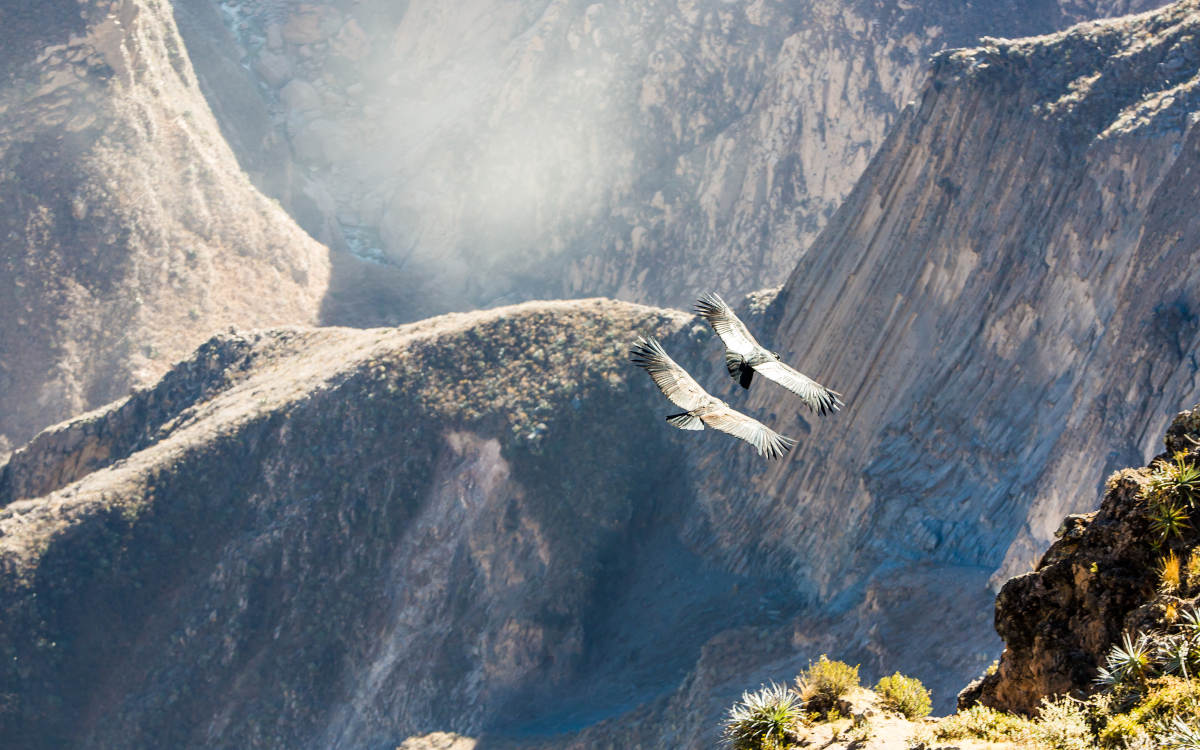
The Andean condors found in Colca Canyon have a wingspan of 10.5 feet.
Along with Gocta Falls, Kuelap is a star attraction of the Chachapoyas area of Peru. This ruin, known as Machu Picchu of the north, is a pre-Inca fortress that was once occupied by the Chachapoyas people. A hike to this spectacular site is a challenging journey, but it’s met with huge rewards once you get to explore the storied settlement of Kuelap. Kuelap is actually listed among the 7 wonders of Peru, and is located in the Amazonas region to the north of the country. It’s easy to see why it’s such a revered place once you traverse its buildings, passages and towers mystically perched in the subtropical landscape.
The 1 day Kuelap Trek sets off from the town of Chachapoyas and the trailhead is in the village of Tingo. The trail is very well-marked and takes you on some steep inclines with designated stops along the way to rest. The trail is largely unshaded and takes you past the green mountains leading to the ruins, edged on the limestone ridges besides the Utcubamba River. After reaching the ruins, travelers may descend back down to Tingo, or spend the night in the nearby guesthouse and catch a morning bus back to Chachapoyas.
This Kuelap trek is rated as moderate. It can be difficult and require some stamina as it is mostly uphill for the entire time to the Kuelap ruins. You gain about 3,970 feet of elevation in less than 6 miles. The good part is there are nice shaded rest stops along the way, the trail is clearly marked and it doesn’t reach elevations that are cause for concern in terms of altitude sickness. Anyone with uphill hiking experience should be able to do this hike. Of course, be sure to bring plenty of water and snacks.
Gocta Falls, or Catarata del Gocta, is one of the top 10 tallest waterfalls in the entire world. Majestically hidden in the Amazonas region of northern Peru, this plummeting cascade reaches 2,530 feet (771 m). A trek to these falls is rewarded with a refreshing dip for the adventurous, or at the very least a stunning photo from the base of the falls. Prepare to get wet as these falls can create quite the mist around them. Though this waterfall was the pride and joy of the people of the Chachapoyas area since ancient times, tourists had no idea about them until 2002.
This trek launches from Chachapoyas, a town in the subtropical highlands of northern Peru. The trailhead is located in the village of Cocachimba from which point you’ll trek through forested and open pathways with beautiful mountains and cliffs in view. You will get different vantage points of Gocta Falls throughout your trek, seeing them from every angle of their glory. Once you reach the falls you will have plenty of time to enjoy them before heading back to Cocachimba.
The trek to Gocta Falls is rated as moderate. There are some uphill and downhill sections both there and back, but the trail does not exceed 8,300 feet in altitude, which means altitude sickness should not be too much of an issue, especially if you’ve spent a few days acclimating or visited the Cusco area prior. There will be some rocky ground throughout so be sure to wear good hiking boots and you should be golden.
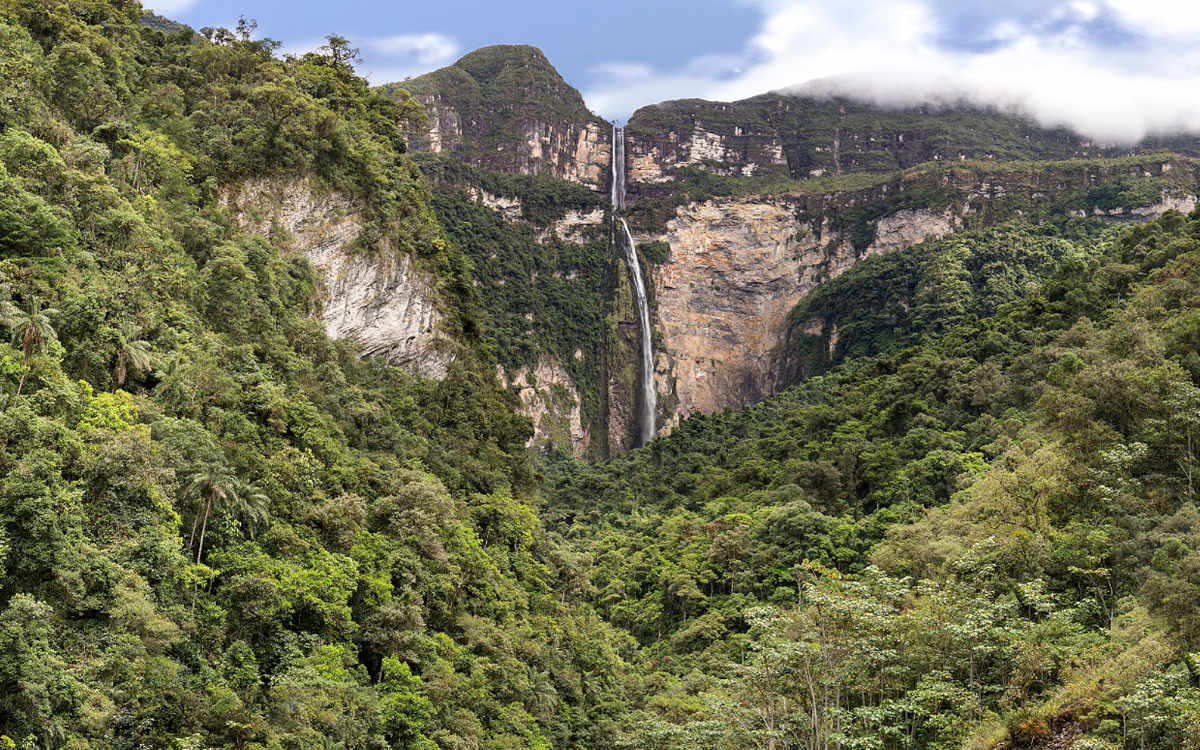
At 2,530 feet, Gocta Falls is one of the top 10 tallest waterfalls in the world. Image: Catarata de gocta.jpg by Srooose under the CC BY-SA 4.0 License. Cropped, compressed and resized from original.
If you want a unique, “trippy” hike experience, head to Marcahuasi. This Andean plateau, located just a few hours from Lima, is known for its stone forest, bursting with unique rock formations that are shrouded in mysticism. Visitors trek here from near and far to marvel at the otherworldly formations (believed by some to be placed there by aliens) and meditate in one of the many energy vortexes. Spiritualism aside, this is an excellent spot for adventure seekers to see some stunning natural scenery, check out the impressive ancient ruins, visit the ethereal Laguna Huacracocha, camp beneath the stars, and even take a mountain biking or horse riding tour.
The Marcahuasi trek launches from the capital city of Lima by car to the trailhead in the town of San Pedro de Casta. From here, you’ll trek through rocky mountains, beside local farms, and make stops at the many viewpoints along the way of the valley below. Once at Marcahuasi, most set up camp at the sandy plateau called the Amphitheater to watch the sunset and marvel at the giant rocks surrounding them. However, you can also trek right back down to San Pedro de Casta after checking out the area if you don’t want to camp.
This trek is rated moderate as it is fairly steep and reaches elevations exceeding 12,000 feet. While this isn’t incredibly high altitude, it can feel more intense since you are coming from Lima, which is at sea level. Anyone with experience hiking, especially some experience being at higher elevations, should have no problem with this trek. Just take your time, pack water and brace yourself for one of the most intriguing sites in Peru. Also, though this area typically has lots of sunshine, the trek can get a bit chilly so be sure to bring layers.
The Laguna 69 hike is absolutely stunning. It is one of those hikes that you will daydream about for the rest of your life because of its sheer beauty. The expressive trees covered in moss, dainty waterfalls trickling into gushing rivers, and vibrant crystal blue lakes hugged by glaciers make you feel like you’re in a mystical fairytale. That being said, this is a tough hike due to both gradient and elevation. But, at least you will be rewarded with unbelievable beauty every step of the way. It is easy to see why this is considered one of the best treks in Peru.
The hike launches from the mountain city of Huaraz and after a jaw-droppingly gorgeous drive you will find La Cebolla trailhead in Huascaran National Park. From there you will take an uphill trail and some difficult switchbacks past the gorgeous treasures of the Cordillera Blanca (White Mountain Range). See numerous lakes, rivers, waterfalls, valleys, and lush greenery until you reach the ultra blue waters of Laguna 69, with snow capped mountains jetting out of it.
The trek to Laguna 69 is considered strenuous. The trail starts off quite gradual as you hike through the valley; but once the switchbacks hit, the uphill climb plus the altitude can be very challenging. There is an especially difficult set of switchbacks toward the end where the rocky trail sharply increases by 700 feet. It is very important to acclimate for 2-3 days before you do this hike as it reaches over 15,000 feet. Once acclimated, anyone with a good level of physical fitness, uphill hiking experience and a motivated attitude should be able to do this trek.
Laguna 69 is the most popular hike in the Huaraz area, and it’s easy to see why.
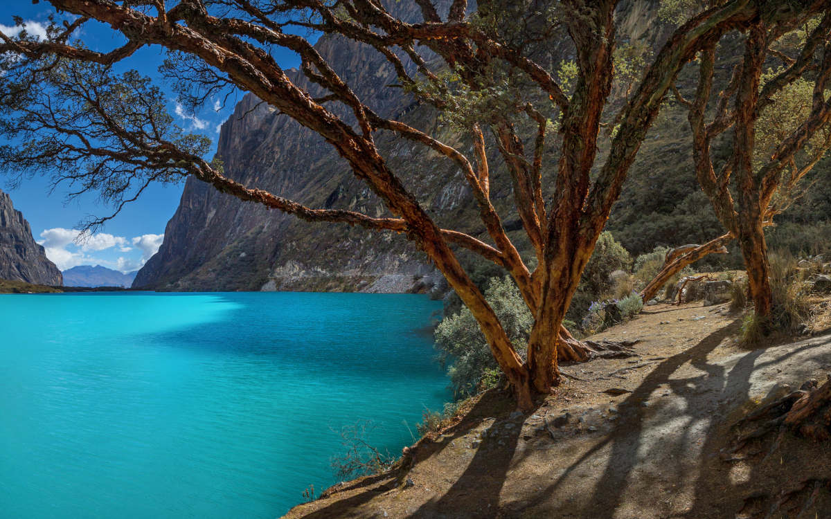
Laguna Paron is the largest of the 882 glacial lakes in the Cordillera Blanca mountains of Peru. Though often overshadowed in popularity by Laguna 69, it’s another stunning option if you have an extra day in the Huaraz area. This icy turquoise lake is located at 13,778 feet above sea level (4,200 m) and is about 2 miles long and 2,297 feet wide. The trail is typically less trafficked than others in the area, so you may just have this slice of mountain paradise all to yourself. After a bit of challenging uphill trek, you can find your perfect rock and sit and marvel in silence at the beauty of this special Peruvian laguna.
The trek launches either from the city of Huaraz (2 hr 25 min car ride), or the city of Caraz (45 min car ride). You will be dropped in Pueblo Paron then walk 15 minutes more until you reach the trailhead, which will take you about 3 hours to the lake. Traverse beautiful mountain trails with 360º vistas of the Cordillera Blanca along the way. Once you take your final climb and get your fix of the Laguna, you head back down the same way.
The trek to Laguna Paron is rated as moderate. Overall it is considered one of the less challenging hikes of the area, largely due to the fact that it is lower in elevation than hikes like Laguna 69. It will still be a bit steep in areas as you gain almost 3,000 feet in elevation, so there are some challenging parts along the way. Good hiking shoes, lots of water, and two or three days of acclimating and you should be find on this beautiful trek.
Machu Picchu Mountain, also known as “Old Mountain,” is one of the hikes that you can do within the ruins of Machu Picchu. It takes about 2 hours to reach the summit and 1.5 hours to go back down so it’s good to give yourself around 4 hours for the trek. At 10,100 feet, it’s the highest summit to hike within Machu Picchu and gives you incredible views of the ruins. You can add this hike on before or after your citadel tour, or return to Machu Picchu a second day to really focus on the hike and soak it in. Permits for Machu Picchu Mountain sell out quickly, so they must be purchased around 6 months ahead of time during the high season (April-September).
To get to the trailhead you have to follow the upper trail leading to the guardhouse of Machu Picchu then take a path through agricultural terraces until you get to the Warden’s Hut, which is where the trek begins. Once you show your passport and give your entrance ticket, you’ll enjoy a wide and well-marked trail through lush cloud forest, which gradually becomes more narrow and steep as you get to the summit. Once at the summit you come back down the way you came and end in Machu Picchu.
The difficulty level for Machu Picchu Mountain is considered strenuous. This is because you gain over 2,000 feet in a short period of time. You will ascend steep switchbacks and lots of steps to get to the summit so it definitely is a workout. There are lots of places to stop and rest along the way, but pace yourself, drink lots of water and enjoy the beauty that is Machu Picchu Mountain.
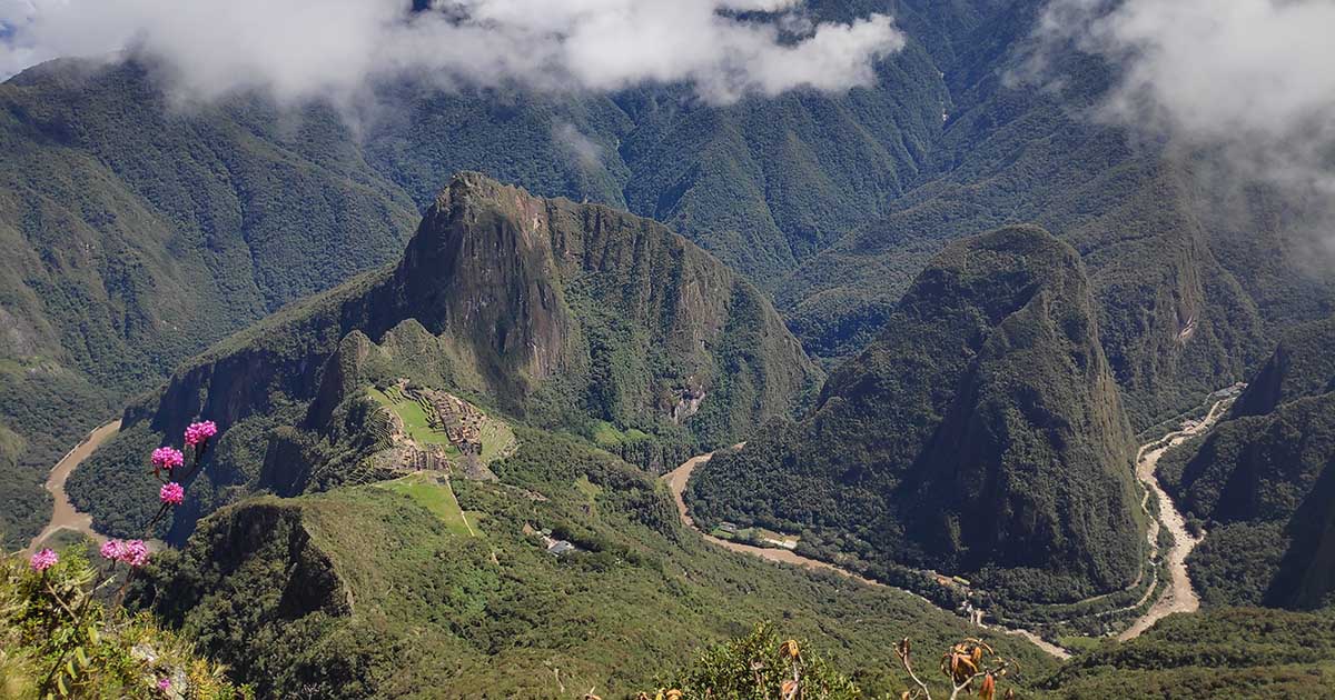
Machu Picchu Mountain Is the tallest summit to climb within the Machu Picchu ruins. Photo by Ana Castañeda of Peru for Less.
Machu Picchu Tours:
Yet another fantastic option for a day hike in the Huaraz area is Laguna Churup. This hike is less popular than Laguna 69 and Laguna Paron, but some favor it as it is more of a short, sweet, technical trail rather than a long, extensive, straightforward one. This hike has scrambling and even ropes for security as you traverse near a waterfall, which is not as challenging as it sounds and can add a rush of adventure to the experience. This trek is also shorter and a bit lower in elevation than some other treks in the area so it’s a good hike to ease you in (but still be sure to acclimatize).
The trek launches from Huaraz and a 45 minute transfer takes you to the trailhead in Pitek. From here you’ll start off pretty steeply on steps then the uphill trail sort of levels out and you can see views of valleys, mountains and waterfalls. There will be a fork in the trail from which point you have the option to do the technical climbing to the right or take a more steady trail to the mirador on the left. You then reach the beautiful Laguna Churup, which usually has a mist surrounding it – adding a magical touch to the blue-green lake that sits at 14,600 feet.
This trek is generally considered moderate as it is shorter and an easier gradient overall. The rock climbing area can definitely add a challenge to the experience, but many say this rope climbing part is actually quite easy. However, to someone who is not acclimated and dislikes climbing, this trek would be rated as strenuous. Luckily, there is a detour around the rock climbing part so it is not required, but this detour to the Mirador is quite steep and can be one of the more challenging parts of the trail. If you have some experience scrambling and have acclimatized for 2 or 3 days you should have no problem with this trek.
Rainbow Mountain, also known as Vinicunca in Quechua and Montana de Siete Colores in Spanish, is a multi-colored mountain in the Andes of Peru. The mountain’s unique mineralogical composition gives different colors, like pink, white, red, green, brown and yellow. It’s quite a sight to behold, which is why this truly unique geological wonder is gaining popularity exponentially. It is increasingly being considered one of the best treks in Peru. The hike to Rainbow Mountain is difficult but takes you through some gorgeous valleys and imposing mountain passes to the spectacular site.
Related Tours:
The Rainbow Mountain hike launches from Cusco and after a 3.5 hour drive you reach the trailhead. Once at the trailhead you’ll be going uphill the entire time, though it’s not too steep. Along the way you’ll see green valleys, local villages, lots of adorable alpaca and even get to see the sacred Ausangate Mountain in the distance (Rainbow Mountain is a popular detour for hikers of the 6-day Ausangate Trek). Once you reach Rainbow Mountain you’ll have time to admire and learn about the famous painted hills before heading back down. It takes about 2 hours to the top and an hour back.
This trail is rated strenuous due to the high elevation (17,060 feet is no walk in the park). The gradient gets especially steep in the final 1,000-foot ascent so you will want to take your time, pause to keep your heart rate at a normal pace and drink water whenever you need. Acclimatizing 2-4 days in Cusco is an absolute must before you embark on this trail. If you know what you’re getting into in terms of altitude and prepare your body properly you will be fine on this trail.
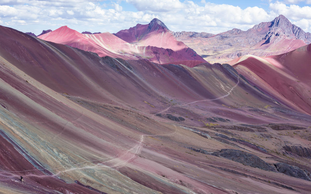
The Rainbow Mountain Trek reaches an elevation of 17,060 feet. Photo by Alicia Gonzalez.
Moray and Maras are two of the most popular sites in Peru’s Sacred Valley. This hike allows you to tour both in a memorable 3 hours among ruins, nature and salt. Moray is an archaeological site comprising circular terraces that were once used by the Inca as experimental agricultural zones. The Maras Salt Pans have been used to harvest salt since before the Inca and each salt pond is still owned and operated by local families. There are over 5,000 salt pans that you will be able to observe and you can even buy some salt as a souvenir.
This experience launches from Cusco or Ollantaytambo and typically the hike itself begins from the Moray Archaeological Site. You’ll have time to explore the site then you will take fairly flat terrain across a high plain to the village of Maras. From the village you’ll descend into the gorge of the valley where you will find the salt pans. After touring the Maras Salt Pans from different viewpoints you will continue descending down to the Urubamba river where your transfer will take you back to Cusco or onto your next Sacred Valley destination.
This hike is considered easy, as the gradient is either level or downhill, the duration is short with a total of 2-3 hours of hiking, there are lengthy stops along the way, and the altitude does not exceed 11,500 feet. It is still recommended to acclimate in Cusco before any physical activity, after which this hike is a great option for those who want a simpler hike. The Maras Moray Trek is also a great option for families.
Huayna Picchu is the most popular hike within the ruins of Machu Picchu. Huayna Picchu translates from Quechua to “young peak,” and is sometimes spelt as Wayna Picchu. A hike to the summit takes around 1 hour and 40 minutes and has some steep, narrow sections as you go uphill. Besides the iconic views of Machu Picchu from its 8,835 foot peak, this trail grants you access to the fascinating Temple of the Moon, which was a ceremonial site that was once used by the Inca. Due to its popularity, permits for this hike do sell out quickly, so it’s important to secure your spot 6 months in advance during the high season (April-September).
This trailhead for this trek can be found behind the Sacred Rock along the lower tour circuit of Machu Picchu. From the starting point, you will follow a winding trail and take the lower trail first to the Temple of the Moon, then go back and take the steep upper trail to the top. On this path you’ll find some difficult switchbacks, and narrow walkways and tunnels to the summit. Once at the summit you can enjoy the stunning views of Machu Picchu before taking the trail sharply back down to the citadel.
Huayna Picchu is rated as moderate, as it is at a lower elevation and overall the hike is quite short. There are, however, some challenging steep sections. The trail becomes very narrow, so it can be difficult for anyone who is afraid of heights or is prone to vertigo. If some narrow uphill steps don’t alarm you, this is a very enjoyable moderate hike. If the thought of narrow trails makes you very nervous, you may want to opt for another trail. Machu Picchu Mountain or even a walk to the Sun Gate or Inca Bridge are all good alternatives.
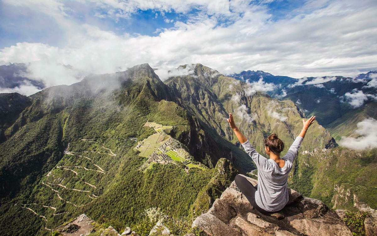
Be sure to secure your spot on the Huayna Picchu hike 6 months in advance, permits sell out quickly. Photo by Peru for Less.
Another amazing day trek in Peru is the one to the beautiful Lake Humantay. Located a 3-hour drive from Cusco, this remote lake is known for its bright turquoise waters and crown of snow-capped mountains. It’s considered one of the prettiest lakes in Peru and certainly one of the best day trips from Cusco for hikers. The lake is right beside the Salkantay Glacier, and has been considered a sacred natural site since the time of the Inca. This is an excellent adventure tour but also a wonderful opportunity to pay your respects to Pachamama (Mother Earth in Quechua).
The tour launches from Cusco and the trailhead is about 3 hours west by car in the village of Soraypampa. Once at the trail, it is pretty much all uphill to the lake. Along the way you’ll see beautiful valleys, creeks, snow capped mountains, and local flora and fauna. Once at the lake you’ll have plenty of time to relax, enjoy the view of the laguna and glacier and even take a dip if you are so compelled (it will be cold).
The Lake Humantay Trek is considered moderate but can be a bit of challenge due to the elevation and uphill portions. The whole hike is only 45 minutes so it is not too demanding, and you gain just over 1,000 feet in just under 3 miles. It can get steep and a bit slippery in some parts so good waterproof hiking boots are highly recommended. Like all Andes treks, you should acclimate in Cusco for 2-3 days before hiking.
The hike to Pastoruri Glacier is short but packed with amazing, unique sites. The glacier itself is beside Pastoruri Mountain, which reaches to 17,224 feet (5,250 m). Pastoruri Glacier used to be a popular spot to walk and practice climbing, but that is no longer permitted. The glacier is one of the few in Peru, and is melting rapidly. In fact, you can literally see it melting before your eyes, as it has lost 22 percent of its size in the past 30 years. Regardless, this striking white and blue ice glacier is an awe-inspiring natural phenomenon and totally worth the quick hike to see it if you’re in Huaraz.
This trek launches from the city of Huaraz and you drive through Andean villages until you reach the trailhead in Huascaran National Park. From here the glacier is less than an hour away by foot, though it will take longer with the short stops that you’ll make. You will have a chance to see a small, but very pretty lake called Patococha along the way where you can practice some birdwatching. You will also see huge groupings of the unusual Puya Raimondii plant scattered along the valley. These 50 foot plants are native to the high mountains of Bolivia and Peru, and are known as the “Queen of the Andes.” Once you reach the glacier you’ll have plenty of time to gaze at its beauty and get the perfect photo before you head back to the trailhead.
The hike to Pastoruri Glacier is considered moderate. The trail is well-marked and at only 1.8 miles the hike is very short. Thought it’s a relatively easy hike, it is still very high in altitude with a max of 16,404 feet. If you do not acclimate for 2-3 days before the hike it will feel a lot of more strenuous than it is. Be sure to spend time acclimating, drink lots of water, and take your time and you should have no problem on this hike.
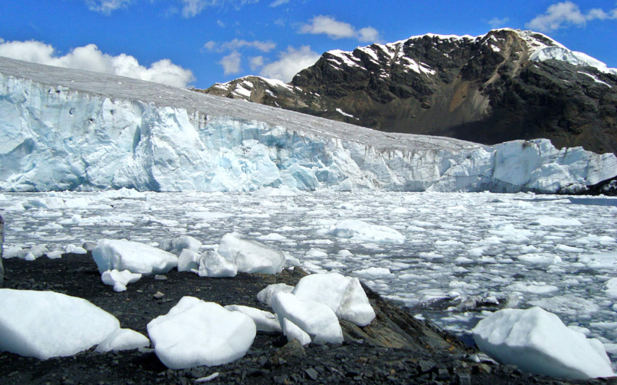
Pastoruri Glacier is a cirque glacier located near Huaraz in Peru. Image: Pastoruri Glacier.jpg by Edubucher under the CC BY-SA 3.0 License. Cropped, compressed and resized from original.
From the glaciers to the mountain passes to the subtropical jungle to ancient ruins, hiking in Peru is an absolute delight. There are times where you will frolic along marveling at the lush beauty and flowers and birds, and other times where you will take it slowly step-by-step, breath-by-breath as you make your way to a high elevation summit. Either way, each of these 27 best treks in Peru will make you stronger and add a memorable bit of natural magic to your life.
Start planning your ultimate Peru hiking trip now! Contact one of our knowledgable travel advisors who will be able to help plan the itinerary and destinations for your trekking vacation across the Andes and beyond.


Email: [email protected]
Sign up to receive our newsletter for great articles, stunning photos, and special deals.


