
The spectacular Sacsayhuamán ruins. Photo by Ruben Hanssen on Unsplash .
At a Glance:
Machu Picchu is one of the most iconic archaeological sites in the world, nestled between the peaks of Machu Picchu Mountain and Huayna Picchu. Built in the 15th century during the reign of the Inca emperor Pachacuti, Machu Picchu is often referred to as the "Lost City of the Incas" due to its rediscovery by American explorer Hiram Bingham in 1911 after being largely forgotten by the outside world.
Machu Picchu is renowned for its stunning architecture, sophisticated engineering, and breathtaking natural setting. The site is divided into two main areas: the agricultural sector, consisting of terraces used for farming, and the urban sector, which includes temples, plazas, and residential buildings. The most famous structures within Machu Picchu include the Temple of the Sun, the Room of the Three Windows, and the Intihuatana stone, a ritual stone associated with the astronomical calendar.
The city's construction is a marvel of Inca engineering, with precisely cut stone blocks that fit together without the use of mortar, showcasing the Incas' advanced understanding of architecture and their ability to adapt their buildings to the challenging mountainous terrain. The site was likely an important religious, ceremonial, and administrative center, possibly serving as a royal estate or a retreat for Inca nobility.
Machu Picchu's remote location and its integration with the surrounding natural landscape add to its mystique and appeal. The site is also part of the larger Machu Picchu Historical Sanctuary, which is home to a rich biodiversity of flora and fauna.
Today, Machu Picchu is a UNESCO World Heritage Site and one of the New Seven Wonders of the World, attracting more than a million visitors each year. It remains a symbol of the Inca civilization's ingenuity and a testament to the enduring legacy of one of the most advanced pre-Columbian cultures in the Americas. Visitors often reach the site via a trek along the Inca Trail or by train from the nearby town of Aguas Calientes, making it a must-visit destination for travelers and history enthusiasts alike.
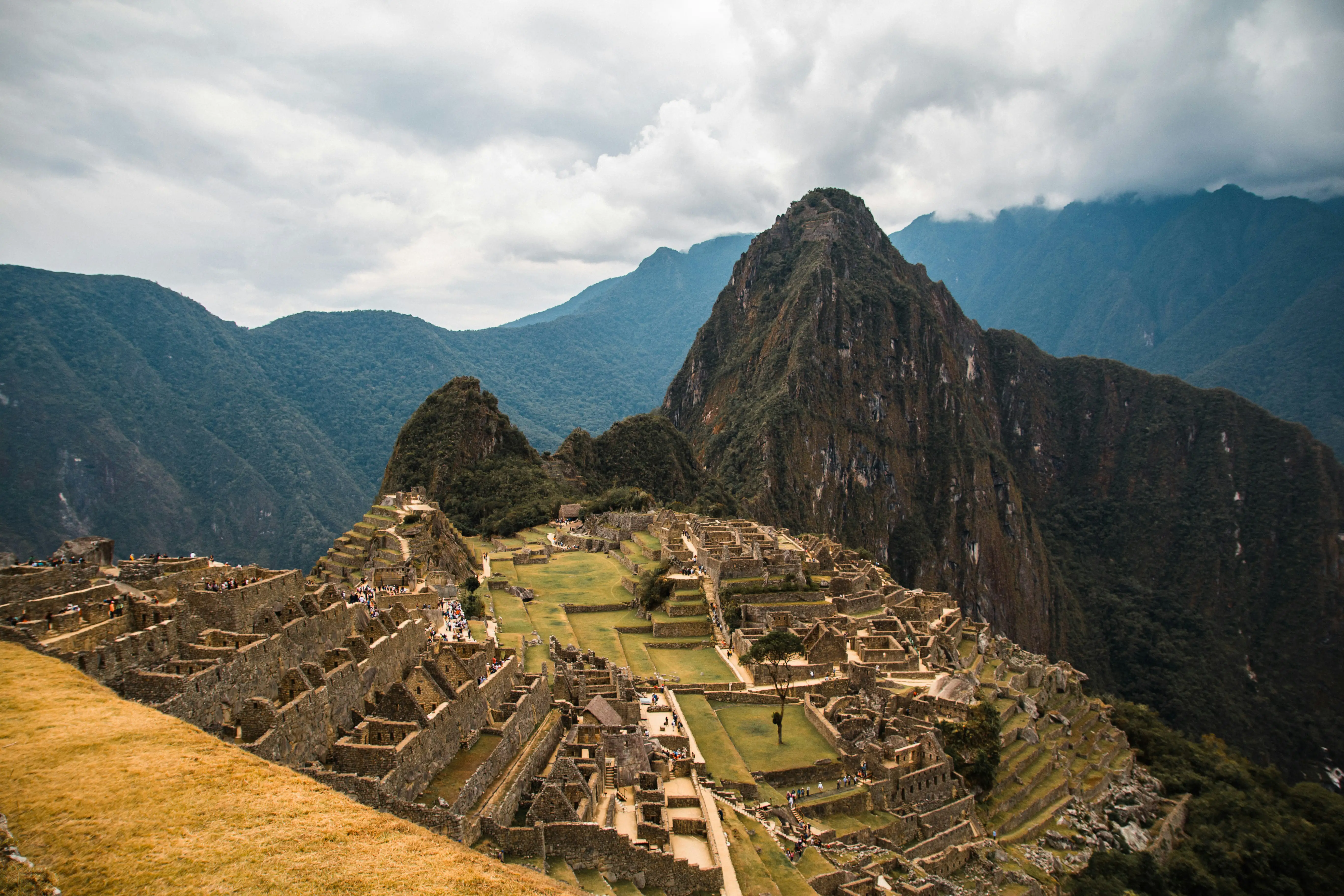
Machu Picchu, one of the seven World Wonders. Photo by Adrian Dascal on unsplash .
At a Glance:
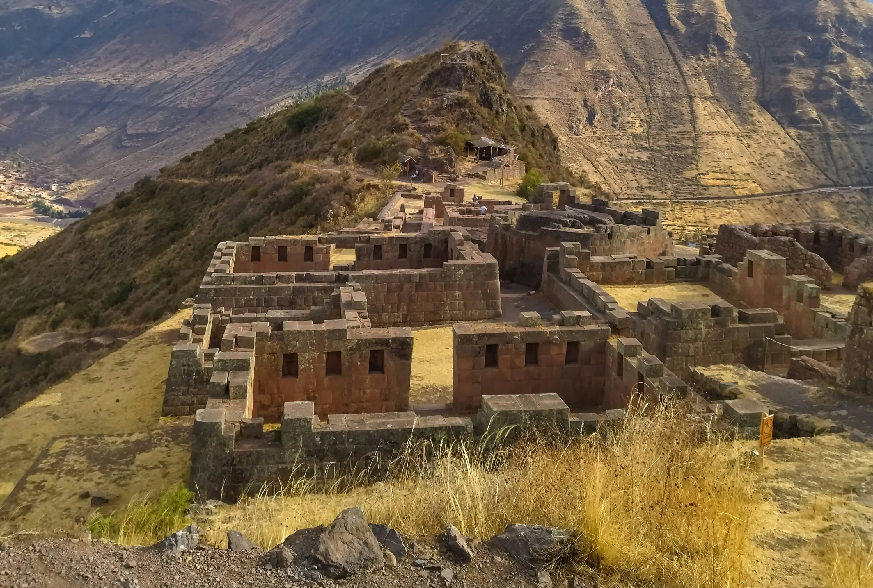
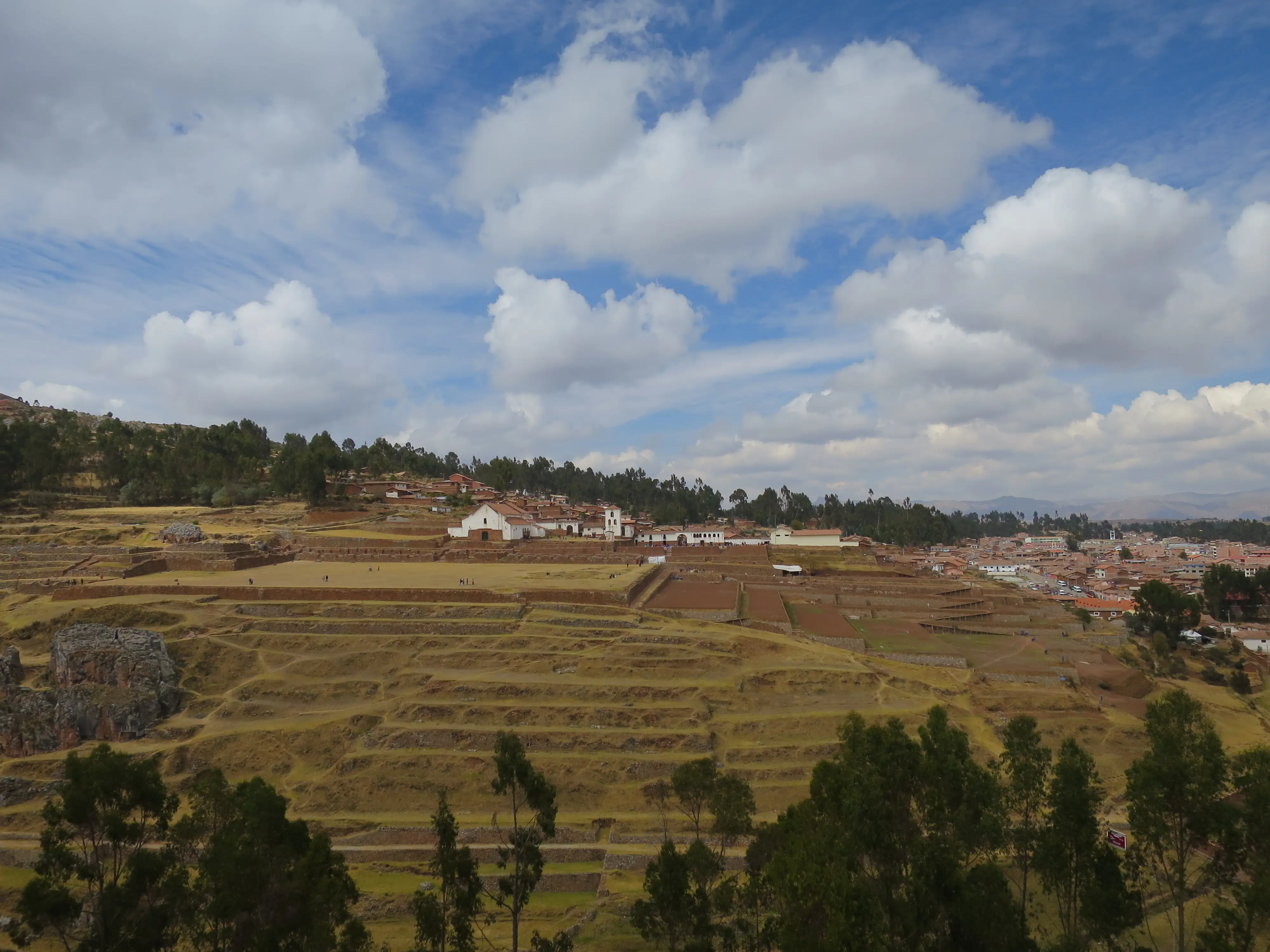
The Ollantaytambo ruins are an impressive and historically significant archaeological site in Peru, showcasing classic Inca architectural features, including finely carved stonework, precise masonry, and the integration of natural landscapes. Known for its extensive agricultural terraces, the site features these structures climbing the hillside, which were used both for farming and for defensive purposes.
The ruins include a large temple complex, including the Temple of the Sun, highlighting the spiritual and architectural sophistication of the Inca civilization. Additionally, the site features a fortress strategically positioned to protect the Sacred Valley. It boasts impressive stone walls and defensive structures that reflect the military prowess and strategic planning of the Incas.
Other notable features include a series of ritual baths and fountains, like the Baths of Ñusta. These were utilized for ceremonial purposes and are a key component of the Inca water management system, highlighting the significance of water in Inca culture. Additionally, the ancient granaries on the site were used to store food supplies, underscoring the Incas' advanced resource management techniques.
The site is also a key point on the Inca Trail to Machu Picchu, serving as a starting point for this iconic trek. This connection adds to the site's significance as both a historical and a functional hub in Inca civilization.
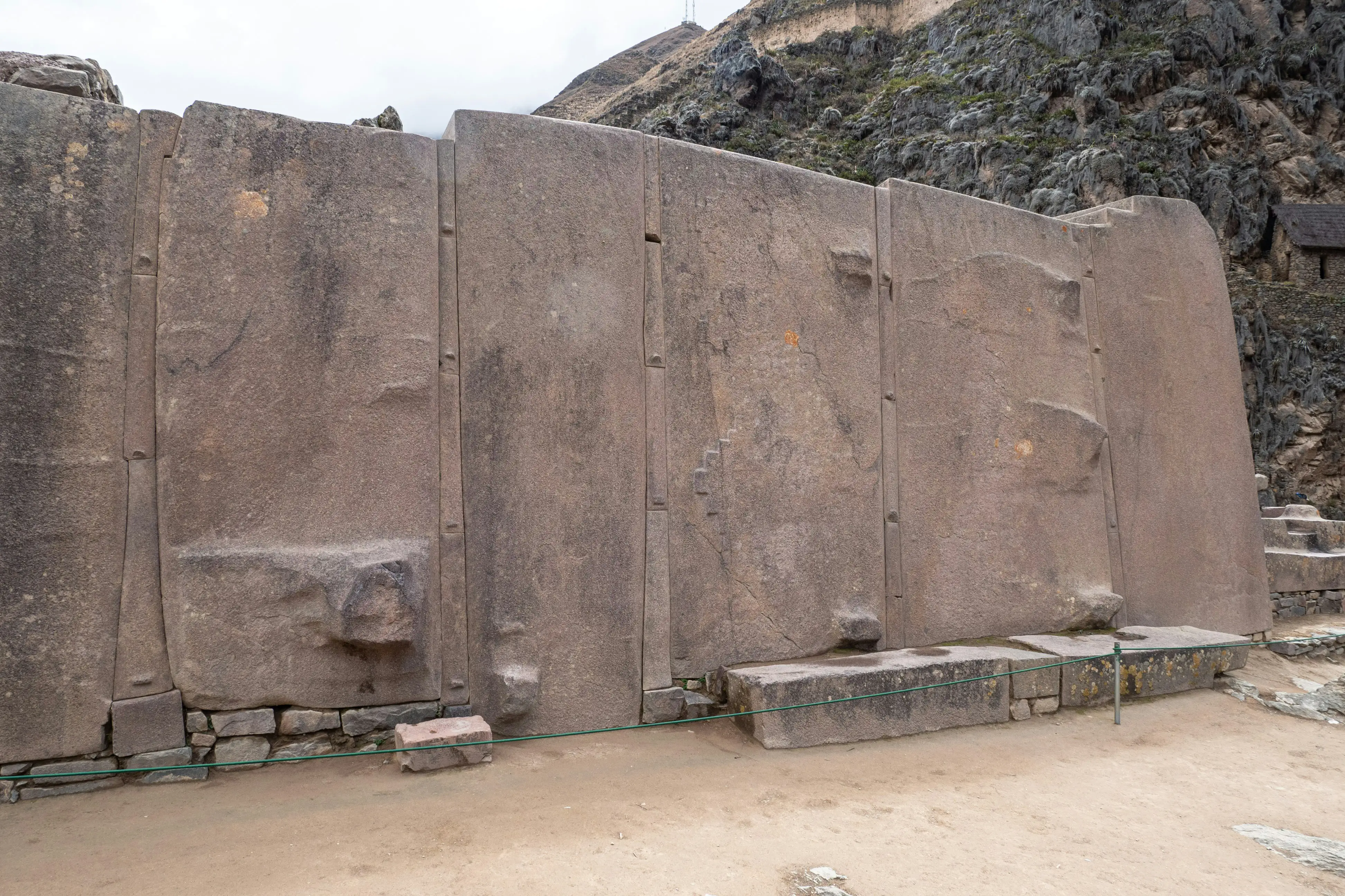
The Temple of the Sun is particularly noteworthy for its precision-cut stones. Photo by Ruben Hanssen on Unsplash .
At a Glance:
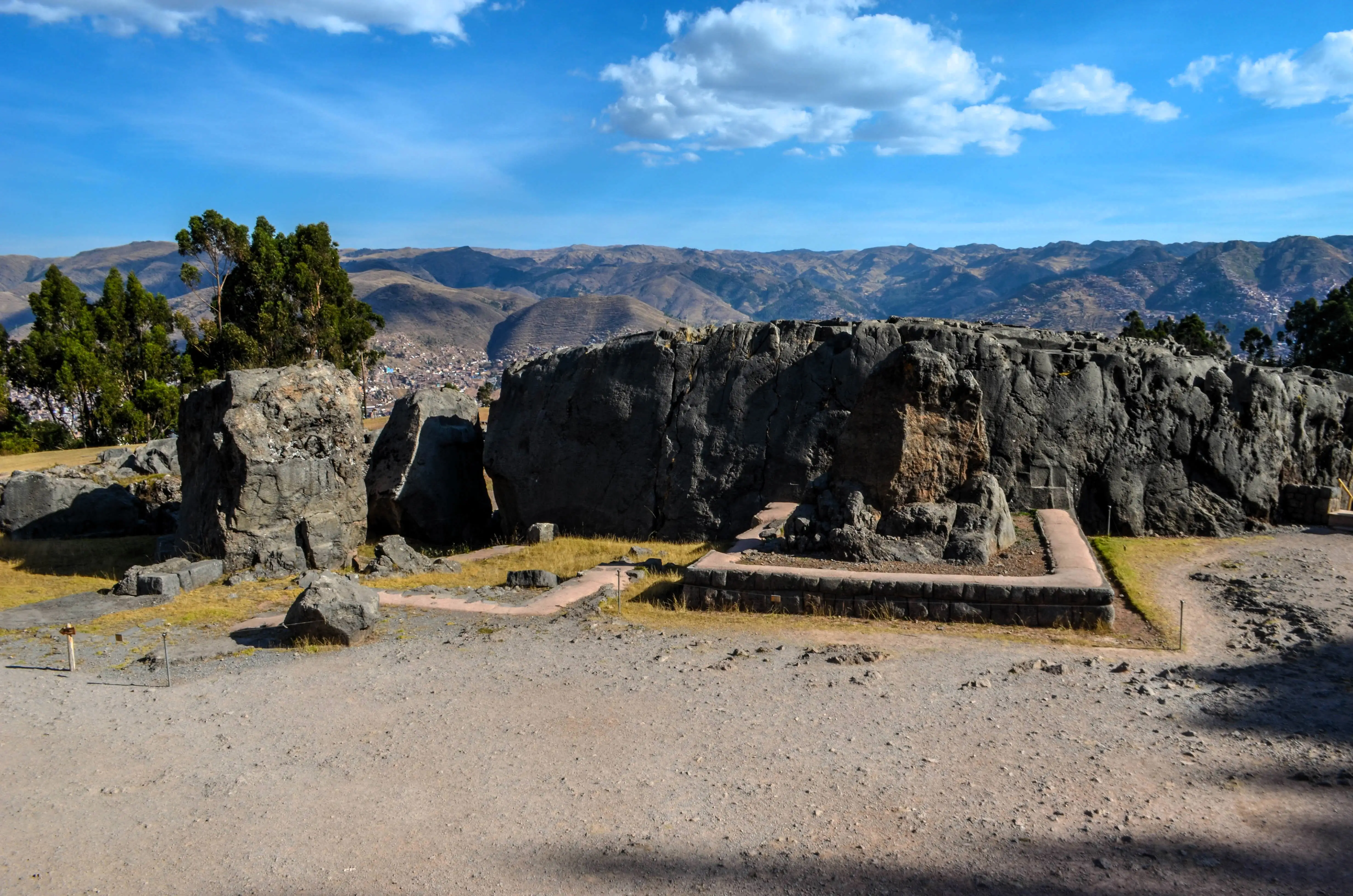
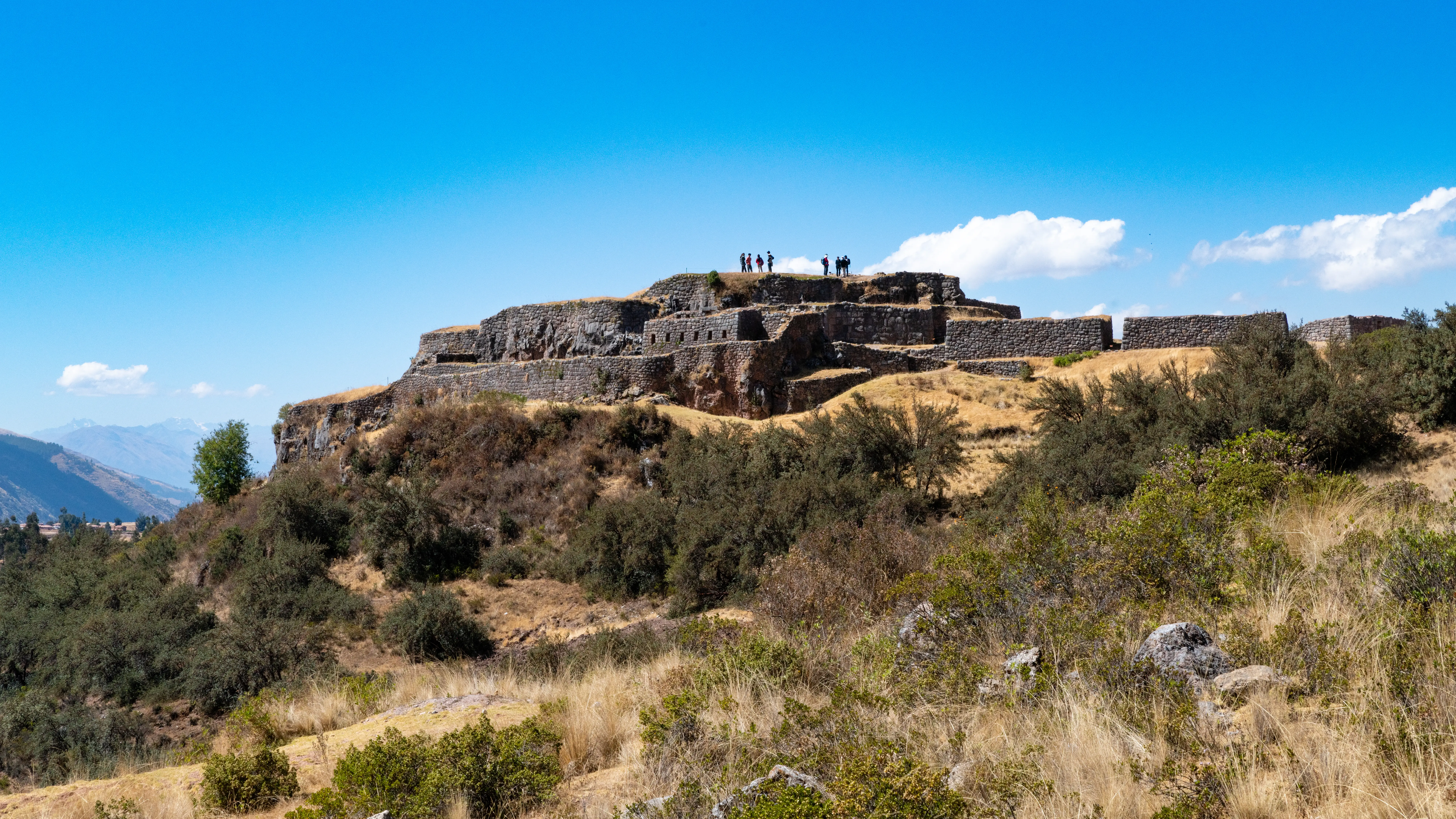
Sacsayhuamán is a stunning archaeological site renowned for its colossal stone walls, constructed from enormous blocks meticulously fitted together. These walls are distinguished by their polygonal shape and the precise craftsmanship that ensures the stones fit so snugly that not even a knife blade can be inserted between them.
It is believed that Sacsayhuamán evolved from a ceremonial center into a strategic military stronghold, playing a crucial role in the resistance against invaders. The site also offers panoramic views of Cusco, making it a popular spot for both history enthusiasts and tourists. The site is an important part of the cultural heritage of Peru and provides insight into the architectural and engineering prowess of the Inca civilization.
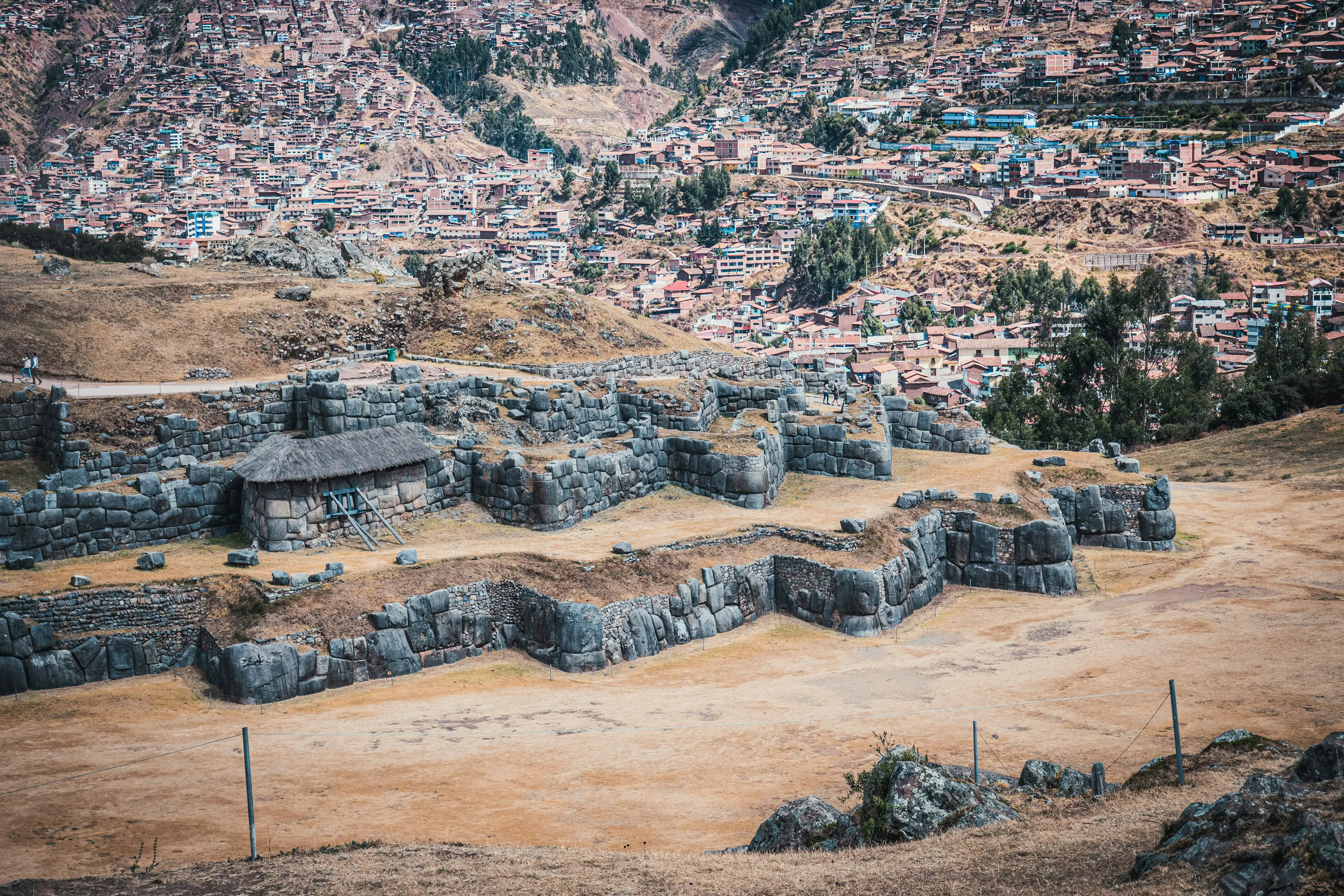
The stunning archaeological of Sacsayhuamán offers panoramic views of Cusco. Photo by Ruben Hanssen on Unsplash .
At a Glance:
Pisac is a significant archaeological and cultural site renowned for its impressive Inca ruins, vibrant market, and picturesque landscapes.
The archaeological site of Pisac includes a series of terraced fields, ceremonial buildings, and fortifications. The terracing system, which features agricultural terraces, highlights the advanced agricultural techniques of the Incas. Both ends of the terraces have beautifully preserved ancient Incan towers that were ancient granaries where food used to be stored. Additionally, the site boasts an impressive cemetery with intricate burial niches carved into the rock.
The town of Pisac is also famous for its bustling market, where visitors can find a wide variety of traditional Andean handicrafts, textiles, and local produce. The market provides a unique opportunity to experience local culture and pick up distinctive souvenirs.
The combination of lush green landscapes and ancient ruins creates a picturesque setting, and for those interested in outdoor activities, there are several hiking trails around Pisac that allow for exploration of both the natural beauty and historical sites of the area.
Pisac is a significant archaeological and cultural site. Photo by Isaac clinton Suca Fuentes on Unsplash .
Cusco Tours:
At a Glance:
Moray is an intriguing archaeological site known for its unique concentric, circular terraces that descend into the earth like amphitheaters. It is believed to have been used by the Incas as an agricultural laboratory to experiment with different crops and growing conditions. These terraces create a variety of microclimates, with temperature variations between the top and bottom levels. This design allowed the Incas to study the effects of different environmental conditions on crops.
Moray's advanced agricultural techniques highlight the Incas' ability to manipulate their environment to optimize crop production. The site may have been used to experiment with various crop varieties and develop strategies for growing food in diverse climates across the Inca Empire.
Set against the backdrop of the Andean mountains, Moray's scenic beauty enhances its allure. The contrast between the circular terraces and the natural landscape creates a visually striking scene, making it a fascinating destination for those interested in the ingenuity of the Inca civilization and their mastery of agriculture.
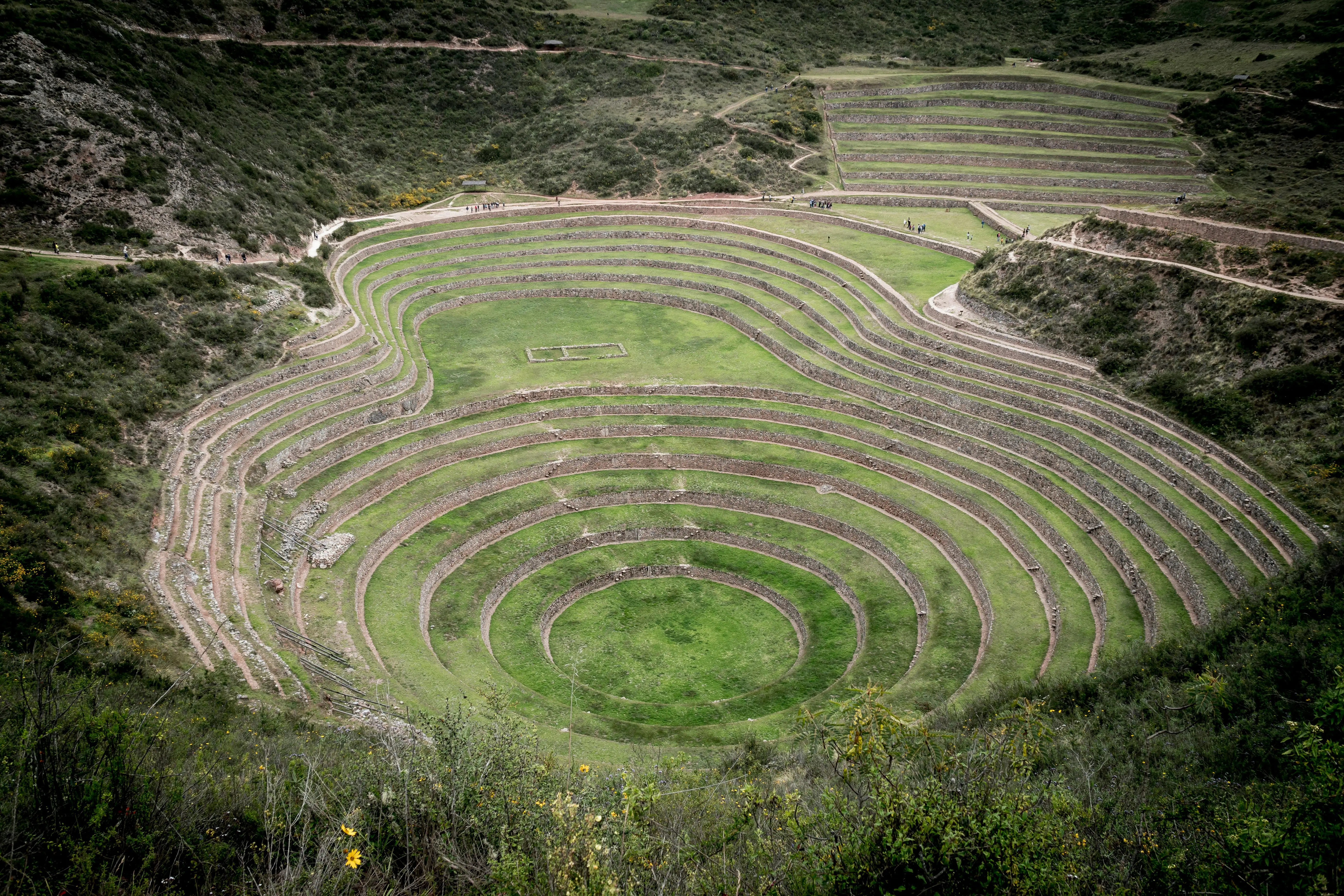
The intriguing ancient agricultural site of Moray. Photo by Willian Justen de Vasconcellos on Unsplash .
At a Glance:
Chinchero is a charming village known for its well-preserved Inca ruins, colonial church, and vibrant traditional markets. Chinchero offers visitors a glimpse into both the ancient and modern cultures of the Andean people. The village is often referred to as the "birthplace of the rainbow" due to its stunning natural surroundings.
The town is also famous for its textile tradition, where local artisans demonstrate their weaving techniques using natural dyes and traditional looms. The blend of Inca history, Spanish colonial architecture, and living traditions makes Chinchero a unique and culturally rich destination in Peru.
Chinchero is a picturesque village in the Sacred Valley of Peru. Photo by Garett Schromm, under the CC BY-SA 4.0 < https://creativecommons.org/licenses/by-sa/4.0 > license, via Wikimedia Commons .
At a Glance:
The Sacred City of Caral-Supe dates back over 5,000 years, making it a contemporary of ancient Egypt and Mesopotamia. Caral-Supe is recognized for its impressive architectural achievements and is considered a UNESCO World Heritage site.
The site features a complex of monumental architecture, including large pyramids, sunken plazas, and residential areas. Its sophisticated urban planning and advanced agricultural practices reveal a highly developed society long before the rise of the Inca Empire. Caral-Supe’s discovery has provided crucial insights into early urban development and social organization in pre-Columbian Peru.
A part of the Sacred City of Caral-Supe. Photo by AlisonRuthHughes, under the CC BY-SA 4.0 < https://creativecommons.org/licenses/by-sa/4.0 > license, via{" "} Wikimedia Commons .
At a Glance:
Qenqo is an important archaeological site renowned for its impressive rock carvings and structures from the Inca civilization. The site features a large, intricately carved rock that was likely used for ceremonial purposes, including sacrifices and offerings. The name "Qenqo," meaning "zigzag" or "labyrinth" in Quechua, aptly describes the complex and winding nature of the carvings found there.
One of the key features of Qenqo is the main rock structure, which is adorned with a series of channels and carvings. This large rock was probably used in various rituals. Additionally, the site includes underground galleries—subterranean tunnels and chambers—that are believed to have held ceremonial significance.
Another notable area within Qenqo is the temple section, which contains carved niches and altars. These features suggest that the site was used for making offerings and conducting religious ceremonies. Along with other nearby sites like Sacsayhuamán and Tambomachay, Qenqo is an integral part of the broader religious and ceremonial landscape around Cusco, offering a captivating glimpse into Inca history and practices.
Qenqo is a notable archaeological site famous for its remarkable Inca rock carvings and structures. Photo by Esmée Winnubst, under the CC BY 2.0 < https://creativecommons.org/licenses/by/2.0 > license, via Wikimedia Commons .
At a Glance:
Puca Pucara is an archaeological site known for its well-preserved ruins from the Inca period. Its name, which means "Red Fort" in Quechua, refers to the reddish color of the stones used in its construction.
Puca Pucara is believed to have served as a military outpost or a ceremonial complex. The site features a series of terraces, walls, and gates that suggest it played a strategic role in the Inca Empire, possibly overseeing and controlling access to Cusco. The site also includes remains of watchtowers and storage areas, reinforcing its function as a defensive and logistical center.
The layout of Puca Pucara is characterized by its compact, fortress-like structure, with multiple interconnected enclosures and defensive walls. Its strategic location on a hillside offers panoramic views of the surrounding landscape, adding to its importance as a commanding point in Inca military and ceremonial activities.
The Puca Pucara archaeological site from a distance. Photo by Christoph Strässler, under the CC BY-SA 2.0 < https://creativecommons.org/licenses/by-sa/2.0 > license, via Wikimedia Commons .
At a Glance:
Tipón is an archaeological site known for its remarkable Inca engineering and agricultural terraces. It is one of the lesser-known but highly impressive Inca sites, often celebrated for its intricate water channels and sophisticated irrigation system.
The site features a series of agricultural terraces that are still irrigated by a network of water channels fed by natural springs. These terraces were likely used for agricultural experimentation and crop production, demonstrating the Incas' advanced knowledge of water management and agricultural techniques.
In addition to the terraces, Tipón includes finely cut stone structures and a complex system of aqueducts, fountains, and ceremonial baths. The precision of the stonework and the efficient distribution of water across the terraces highlight the Incas' architectural and engineering skills.
Tipón is also considered a ceremonial site, with some structures possibly serving religious or ritual purposes related to water worship. Its serene setting and the ingenuity of its construction make it a fascinating destination for those interested in Inca history and culture.

Tipón is often celebrated for its intricate water channels and sophisticated irrigation system. Photo by Aga Khan (IT), under the CC BY-SA 4.0 < https://creativecommons.org/licenses/by-sa/4.0 > license, via Wikimedia Commons .
At a Glance:
Maukallaqta, also known as Maukallacta, is an archaeological site rich in historical and cultural significance. The name "Maukallaqta" means "ancient town" in Quechua, reflecting its status as a place of early settlement.
The site is believed to have been an important pre-Inca and Inca ceremonial center, with remnants of temples, plazas, and residential structures. Maukallaqta features a combination of well-preserved stone buildings and circular structures, which are characteristic of the architecture from the region's ancient civilizations.
One of the most notable aspects of Maukallaqta is its strategic location on a hillside, offering sweeping views of the surrounding valleys and mountains. This positioning suggests that it may have served not only as a religious and ceremonial site but also as a place of refuge and control.
In addition to its architectural features, Maukallaqta holds cultural and historical importance, as it is closely associated with various Andean traditions and rituals. Its relatively remote location has kept it less visited than other sites, making it a peaceful and intriguing destination for those interested in exploring the lesser-known aspects of Peru's ancient history.
Maukallaqta is believed to have been an important pre-Inca and Inca ceremonial center. Photo by Ordzonhyd Rudyard Tarco Palomino, under the CC BY-SA 4.0 < https://creativecommons.org/licenses/by-sa/4.0 > license, via Wikimedia Commons .
Lima Tours:
At a Glance:
Choquequirao is a sprawling archaeological site located in the Andes of southern Peru, often referred to as the "sister city" of Machu Picchu due to its similar architecture and grandeur. The name "Choquequirao" means "Cradle of Gold" in Quechua, reflecting its legendary status and the allure it holds for explorers and historians alike.
This ancient Inca site sits on a high ridge, surrounded by breathtaking mountain scenery and deep canyons. It features a complex of terraced slopes, ceremonial buildings, plazas, and stone structures that showcase the advanced engineering and architectural skills of the Incas. The site spans several levels, with impressive stone walls and staircases connecting different areas.
Choquequirao is believed to have been an important political, religious, and cultural center, possibly serving as a retreat for Inca royalty or as a strategic outpost during the Spanish conquest. One of its unique features includes extensive agricultural terraces decorated with white stone figures, such as llamas, which are believed to have held ceremonial significance.
Unlike Machu Picchu, Choquequirao remains less accessible and more remote, requiring a challenging multi-day trek to reach. This isolation has kept it largely unspoiled and less crowded, offering visitors a more intimate and adventurous experience. For those willing to make the journey, Choquequirao provides a fascinating glimpse into the grandeur and mystery of the Inca civilization.
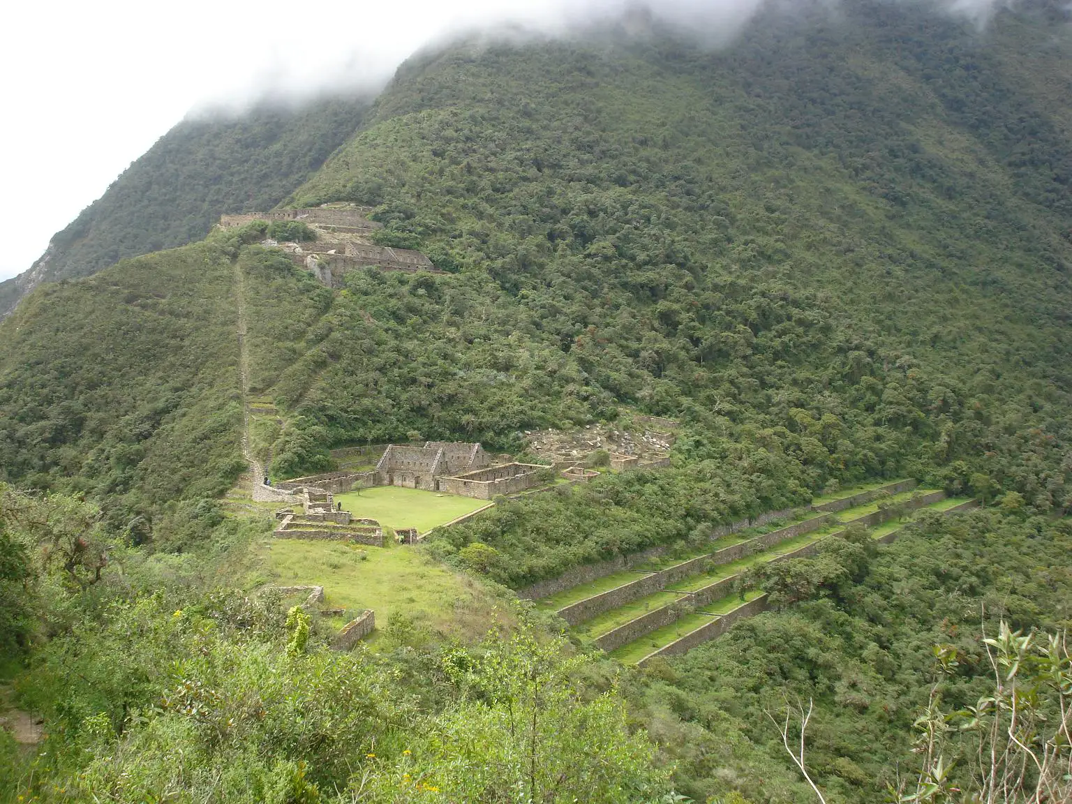
Choquequirao is often referred to as the "sister city" of Machu Picchu due to its similar architecture. Photo by Harley Calvert, under the CC BY-SA 3.0 < https://creativecommons.org/licenses/by-sa/3.0 > license, via Wikimedia Commons .
At a Glance:
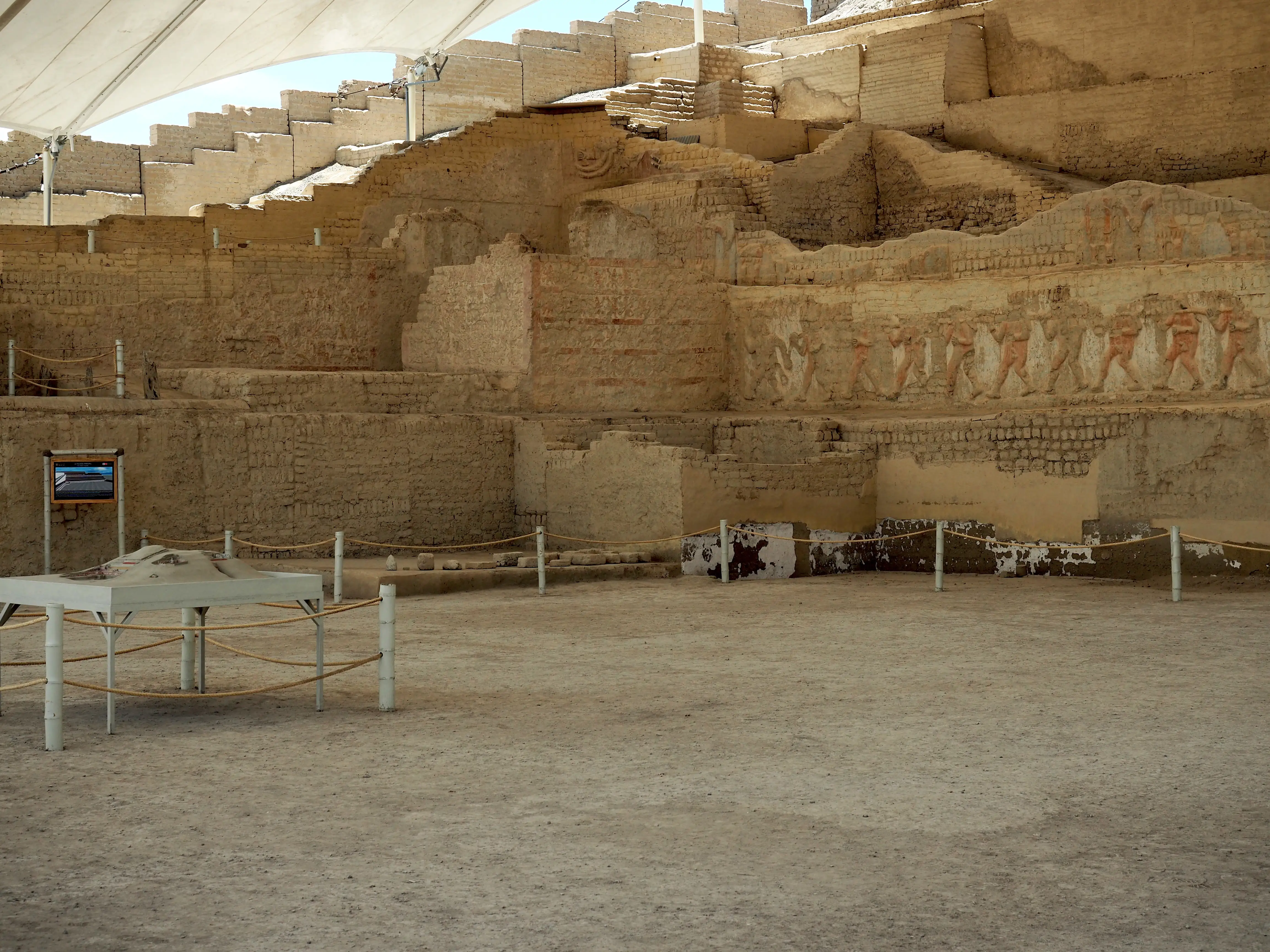
Chan Chan is a vast archaeological site on the northern coast of Peru. It was the capital of the Chimu civilization, which thrived before the rise of the Inca Empire. Spanning approximately 20 square kilometers, Chan Chan is considered the largest adobe city in the world and one of the most important pre-Columbian sites in South America.
The builders constructed the city entirely out of adobe (sun-dried mud bricks), creating a labyrinth of walls, plazas, temples, and residential areas. The layout divides into several distinct citadels, each housing ceremonial rooms, burial chambers, reservoirs, and storage facilities. These citadels were likely the palaces of Chimu kings, reflecting the centralized and hierarchical nature of Chimu society.
One of the most remarkable aspects of Chan Chan is its intricate bas-relief decorations, which adorn the walls of the city's structures. These carvings depict a variety of motifs, including geometric patterns, animals like birds and fish, and mythological creatures, illustrating the Chimu's close relationship with the sea and their artistic sophistication.
Chan Chan was an advanced urban center with a sophisticated water management system that included canals and reservoirs, essential for sustaining the large population in an arid environment. The Incas conquered the city in the late 15th century, which marked the beginning of its decline. Later, the Spanish conquest further deteriorated the city.
Today, UNESCO recognizes Chan Chan as a World Heritage Site, although natural erosion and climate change threaten it. Despite these challenges, it remains a fascinating testament to the ingenuity and cultural richness of the Chimu civilization.
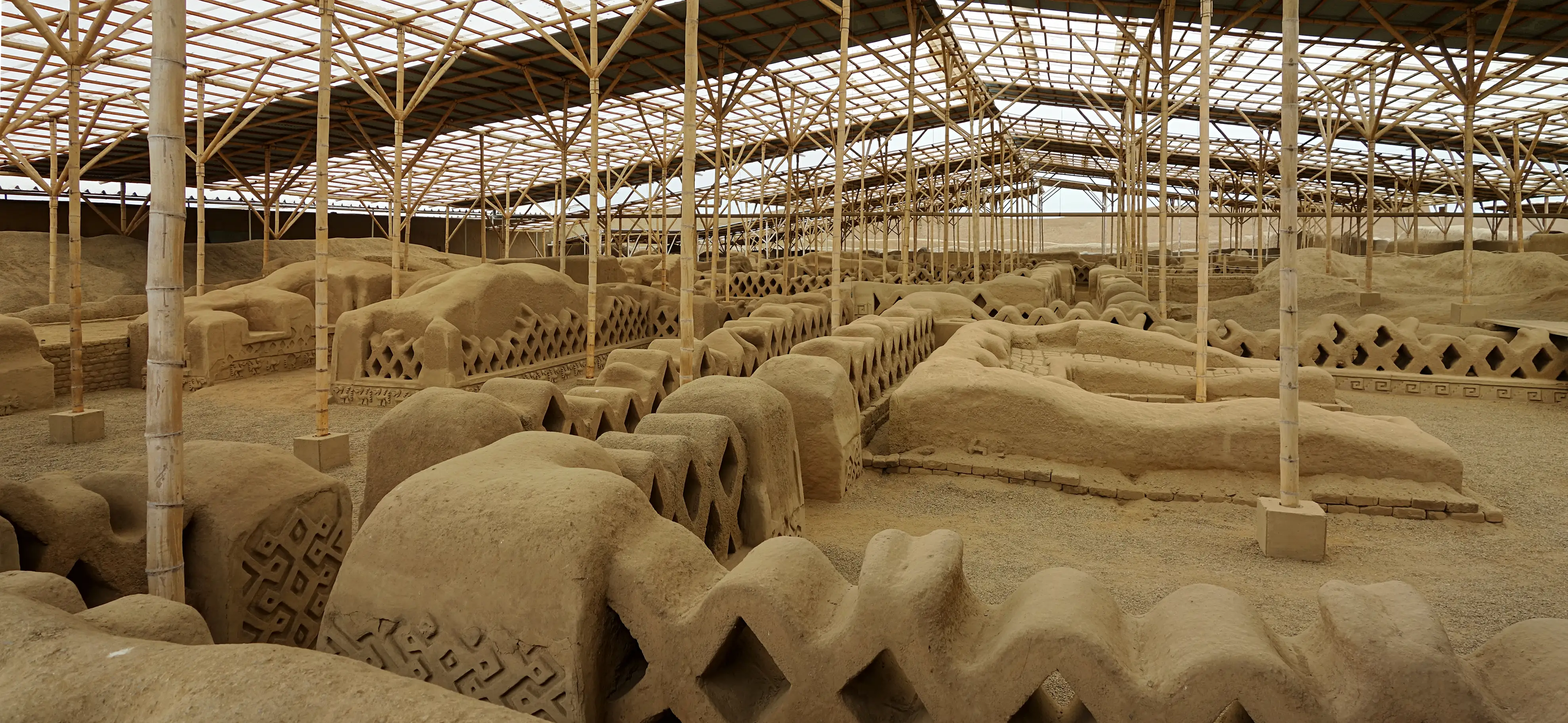
Infrastructure is in place to protect the ruins in the Chan Chan Archaeological Zone. Photo by Velvet, under the CC BY-SA 4.0 < https://creativecommons.org/licenses/by-sa/4.0 > license, via Wikimedia Commons .
At a Glance:
The Lima culture constructed Huaca Pucllana, a pre-Inca pyramid, during their thriving period between 200 and 700 AD. The site's builders constructed an impressive adobe (mud brick) structure in multiple stages, resulting in a stepped pyramid that rises about 22 meters high.
The pyramid complex at Huaca Pucllana functioned as a major ceremonial center and likely also served as a social and administrative hub. It features a series of platforms, plazas, and courtyards, and the layout reflects the sophisticated urban planning and architectural skills of the Lima culture. The site also includes a network of irrigation channels and storage areas, demonstrating the advanced agricultural and logistical capabilities of its builders.
Huaca Pucllana’s distinctive design is characterized by its large, hand-formed adobe bricks arranged in a herringbone pattern, which gives the structure its unique appearance and stability. Archaeologists have uncovered various artifacts, including ceramics, textiles, and remains of sacrificial offerings, which provide insights into the religious and cultural practices of the Lima culture.
Today, Huaca Pucllana is a well-preserved site that offers visitors a glimpse into pre-Columbian history and stands as an important cultural landmark in Lima. The site is also a popular tourist attraction, featuring a restaurant, a museum, and guided tours that highlight its historical significance and ongoing conservation efforts.
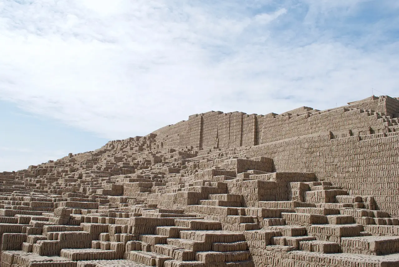
Huaca Pucllana is known for its large, pyramid-like structure made of adobe and clay. Photo by rdlncl on Pixabay .
Peru Tours:
At a Glance:
El Brujo is an ancient archaeological complex located on the northern coast of Peru and is one of the most significant archaeological sites in the region, with a history that spans several pre-Columbian cultures, including the Moche civilization, which flourished between 100 and 700 AD.
The complex consists of several large adobe pyramids, the most famous being the Huaca Cao Viejo. This pyramid is renowned for its intricate bas-relief murals depicting warriors, prisoners, and mythological figures, showcasing the artistic and cultural achievements of the Moche people. These murals are remarkably well preserved, thanks to the dry desert climate of the region.
One of the most remarkable discoveries at El Brujo was the tomb of the Lady of Cao, a high-ranking Moche priestess or ruler. Her elaborately adorned burial, complete with gold, jewelry, and ceremonial objects, provided valuable insights into the role of women in Moche society and the religious practices of the time.
El Brujo also includes other important structures and features, such as Huaca Prieta, one of the earliest known human settlements in Peru, dating back to around 3000 BC. The site's long history and cultural significance make it a vital location for understanding the ancient civilizations of Peru.
Today, El Brujo is an important archaeological and tourist site, with a museum dedicated to the findings and ongoing research at the complex. Visitors can explore the pyramids, view the murals, and learn about the fascinating history of the Moche and other cultures that once thrived in this area.
El Brujo is one of the most significant archaeological sites on the northern coast of Peru. Photo by AlisonRuthHughes, under the CC BY-SA 4.0 < https://creativecommons.org/licenses/by-sa/4.0 > license, via Wikimedia Commons .
At a Glance:
Kuelap is a massive ancient fortress built by the Chachapoya civilization, also known as the "Warriors of the Clouds." Kuelap dates back to around the 6th century AD and is one of the most impressive archaeological sites in the country.
The fortress is perched on a high mountain ridge at an altitude of about 3,000 meters (9,840 feet) above sea level, offering stunning views of the surrounding cloud forest. Kuelap's most striking feature is its massive stone walls, which stretch over 600 meters (1,970 feet) in length and reach up to 20 meters (65 feet) in height in some sections. These walls enclose a vast complex of over 400 circular stone structures, including residential buildings, temples, and public spaces.
Kuelap is believed to have served as a fortified city and a ceremonial center, providing protection and a place of refuge for the Chachapoya people. The site also includes impressive architectural elements, such as narrow entrances, which were likely designed for defense, and intricate stone carvings and friezes that reflect the artistic and cultural traditions of the Chachapoya.
Despite its size and importance, Kuelap remained relatively unknown until the late 19th century and is often compared to Machu Picchu for its historical and architectural significance. However, Kuelap receives far fewer visitors, making it a less crowded and more tranquil alternative for those interested in exploring Peru's ancient heritage.
Today, Kuelap is a popular tourist destination that provides a fascinating glimpse into the life and culture of the Chachapoya civilization and is an essential stop for history enthusiasts and adventurers alike.
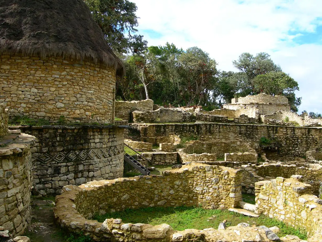
A partial view of Kuelap, a massive ancient fortress built by the Chachapoya civilization. Photo by Elemaki, under the CC BY-SA 2.5 < https://creativecommons.org/licenses/by-sa/2.5 > license, via Wikimedia Commons .
At a Glance:
The Sarcófagos de Karajía are a remarkable set of ancient funerary statues that were created by the Chachapoya civilization, known as the "Warriors of the Clouds," and date back to the 15th century.
The sarcophagi are unique for their anthropomorphic design, standing about 2.5 meters (8 feet) tall, with human-like faces and bodies sculpted from clay, straw, and stone. These statues were placed high on the face of a cliff, overlooking the valley, making them difficult to access and preserving them for centuries. The positioning of the sarcophagi in such a remote and elevated location suggests that they were intended to protect the remains of high-status individuals or leaders from the elements and potential looters.
Each sarcophagus is adorned with intricate details, including headdresses and facial features that reflect the artistic and cultural practices of the Chachapoya. Some of the statues are also painted with ochre, adding to their distinct appearance.
The Sarcófagos de Karajía offer a fascinating glimpse into the funerary customs and beliefs of the Chachapoya people. The location of the sarcophagi, perched high above the ground, symbolizes the Chachapoya's reverence for the dead and their desire to place their ancestors closer to the heavens.
Today, the Sarcófagos de Karajía are an important archaeological site and a popular tourist destination, attracting visitors interested in exploring the rich cultural heritage of the Chachapoya civilization. The site is accessible via a short hike, providing an opportunity to experience the stunning natural landscape and the intriguing history of this ancient culture.
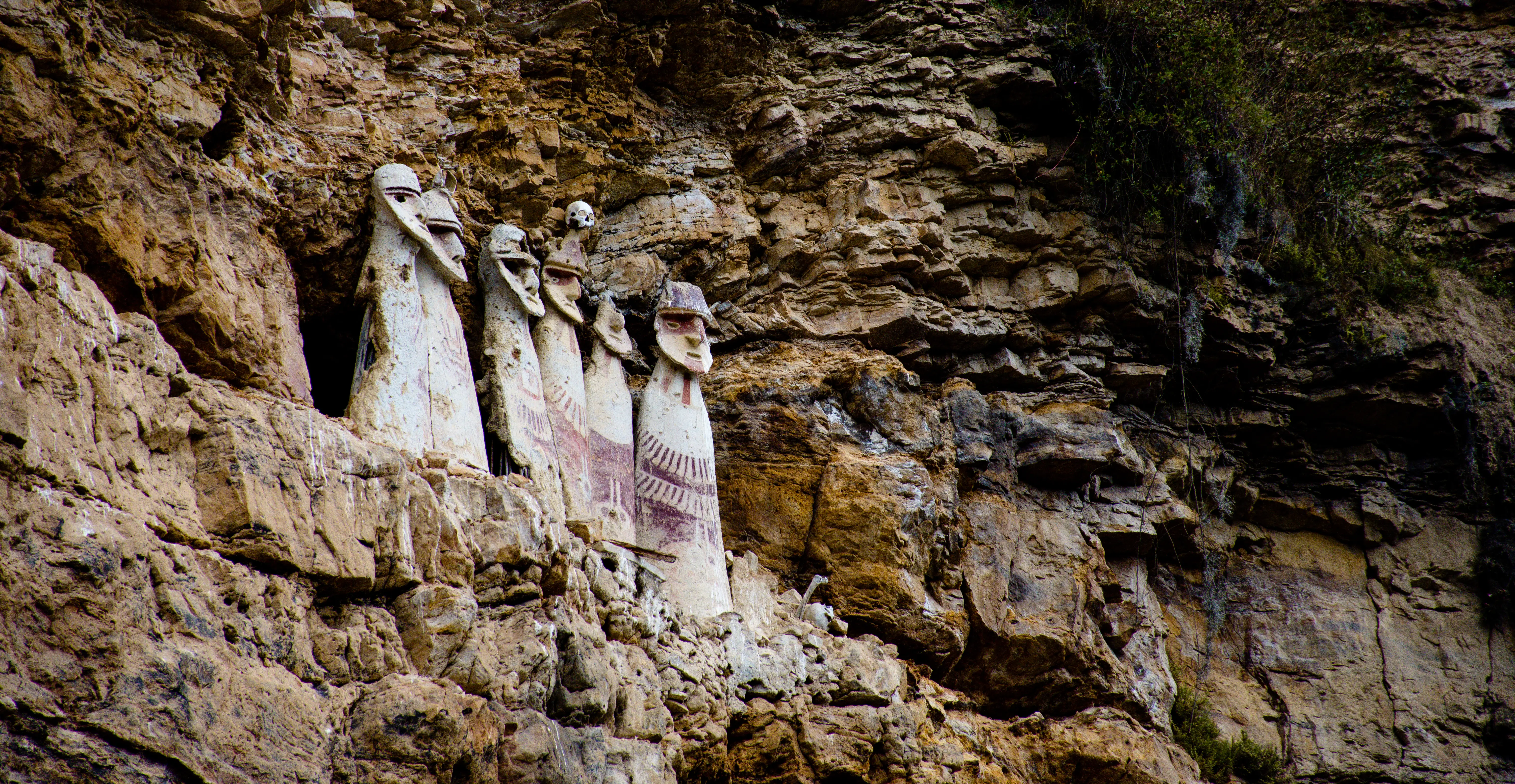
The Sarcófagos de Karajía in the Amazon Jungle of Peru are the remnants of the Chachapoyas culture. Photo by Zadircito, under the CC BY-SA 4.0 < https://creativecommons.org/licenses/by-sa/4.0 > license, via Wikimedia Commons .
At a Glance:
Sipán is an important archaeological site that is most famous for the discovery of the tomb of the Lord of Sipán, a high-ranking Moche ruler whose burial site was uncovered in 1987 by Peruvian archaeologist Walter Alva. This discovery is often regarded as one of the most significant archaeological finds in the Americas due to the wealth of artifacts and the insight it provides into the Moche civilization, which flourished between 100 and 700 AD.
The Lord of Sipán's tomb was a remarkable find, containing an array of gold, silver, and copper ornaments, intricate jewelry, and finely crafted ceramics. These artifacts, along with the remains of several other individuals and animals found within the tomb, illustrate the Moche's complex social hierarchy and their elaborate burial practices. The discovery also revealed much about the Moche's religious beliefs, artistry, and craftsmanship.
The Sipán site itself includes a series of pyramids, known as huacas, made from adobe (mud bricks). These structures were part of a larger ceremonial and residential complex used by the Moche elite. The pyramids and surrounding structures served as both religious and administrative centers, indicating the site's importance in Moche society.
The discovery of the Lord of Sipán's tomb has been compared to that of Tutankhamun in Egypt due to its historical significance and the wealth of treasures found. The artifacts from Sipán are now housed in several museums, most notably the Royal Tombs of Sipán Museum in Lambayeque, which was specifically built to display the treasures from the tomb.
Sipán continues to be a focal point for archaeological research, shedding light on the Moche civilization's influence and legacy in pre-Columbian Peru. The site is also a popular tourist destination, offering visitors the chance to explore the ancient pyramids and learn about the rich cultural heritage of the region.
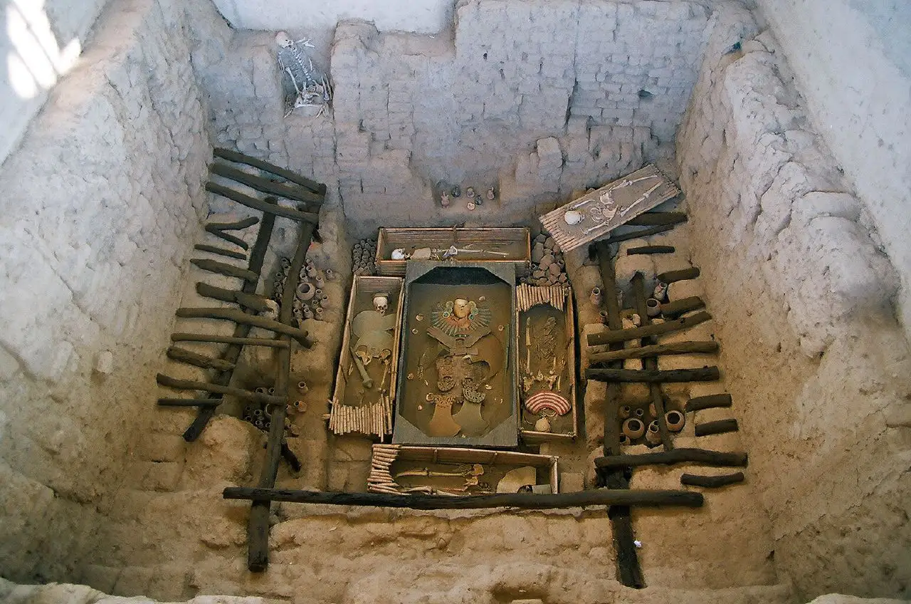
This photo shows the original tomb in situ at Huaca Rajada, Sipán. The ornaments and skeletons are replicas; the originals have been restored and are displayed in the museum. Photo by Bruno Girin, under the CC BY-SA 2.0 < https://creativecommons.org/licenses/by-sa/2.0 > license, via Wikimedia Commons .
At a Glance:
Coricancha, also known as the Temple of the Sun, was the most significant temple in the Inca Empire, dedicated to Inti, the Sun God, and played a central role in Inca religious and ceremonial life.
The original structure of Coricancha was built by the Inca Emperor Pachacuti in the 15th century and was a masterpiece of Inca architecture. The temple was constructed using finely cut and polished stone blocks that fit together so precisely that even a thin blade couldn't be inserted between them. The walls of the temple were once covered in sheets of gold, symbolizing the sacredness and the connection to the sun. Inside, there were also other shrines dedicated to the moon, stars, and other important deities.
When the Spanish conquistadors arrived in the 16th century, they were awestruck by the grandeur of Coricancha. However, they stripped the temple of its gold and built the Church of Santo Domingo on top of its foundations, a symbolic act of conquest. Despite the destruction, much of the original Inca stonework remains intact, and the contrast between the Inca architecture and the colonial Spanish construction is one of the most striking features of the site today.
Coricancha's remaining walls and structures offer a glimpse into the advanced engineering and astronomical knowledge of the Incas. The temple was designed to align with celestial events and played a crucial role in the Inca calendar and agricultural practices.
Today, Coricancha is a popular tourist attraction, drawing visitors who are interested in Inca history, architecture, and culture. The site also houses a museum that displays artifacts from both the Inca and colonial periods, providing a comprehensive view of its historical significance.
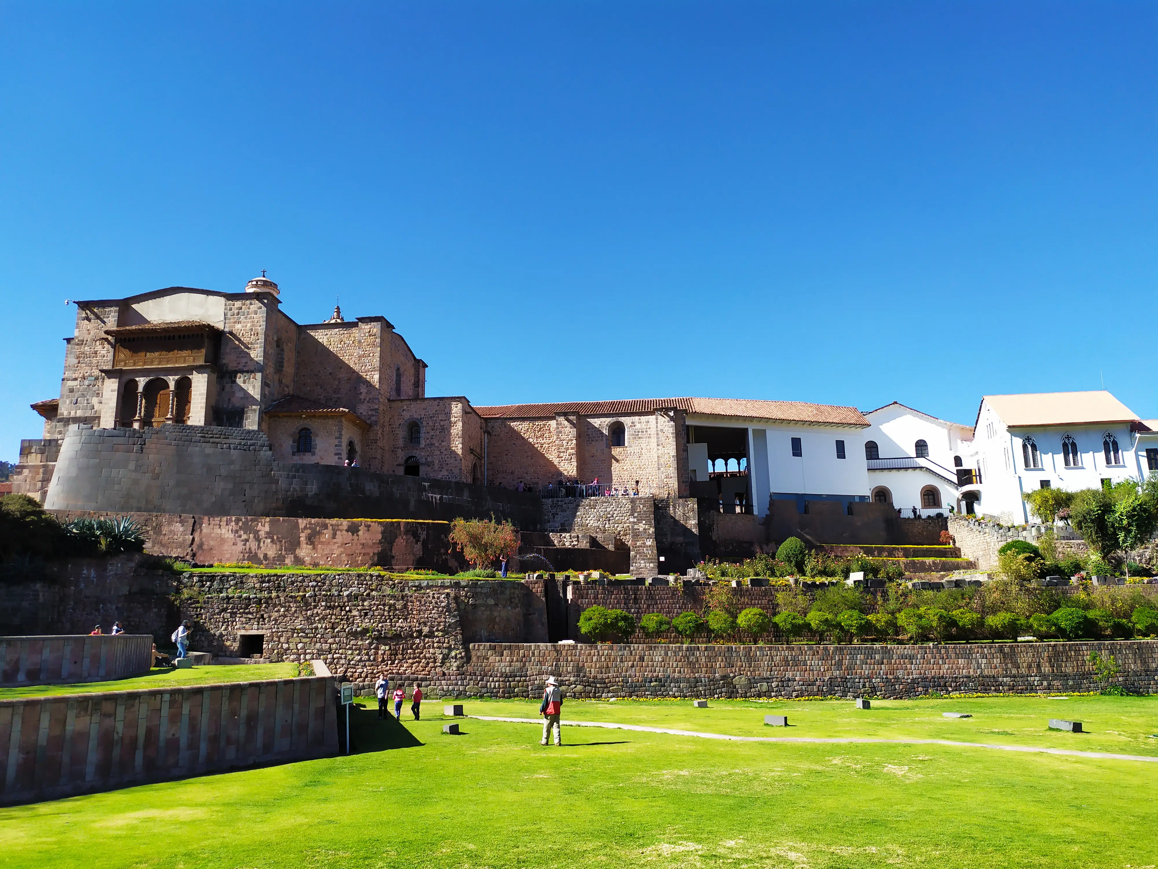
In the 16th century, Spanish conquistadors built the Church of Santo Domingo atop Coricancha's foundations, a symbolic act of conquest. Despite this, much of the original Inca stonework remains, highlighting the striking contrast between Inca and Spanish architecture. Photo by Srsifuentes, under the CC BY-SA 4.0 < https://creativecommons.org/licenses/by-sa/4.0 > license, via Wikimedia Commons .
At a Glance:
Tambomachay is an archaeological site known for its well-preserved Inca ruins and its association with water rituals. Often referred to as the "Bath of the Inca," Tambomachay was likely used as a ceremonial site dedicated to water and possibly as a retreat for Inca nobility.
The site is characterized by a series of terraced stone structures built with the precision typical of Inca architecture. These terraces are integrated with natural springs, and the water flows through a network of aqueducts, canals, and fountains. The engineering behind this water system demonstrates the Inca’s advanced understanding of hydraulics and their ability to manipulate natural landscapes.
Tambomachay's function is believed to have been both religious and recreational. The constant flow of water from the springs, which continues to this day, suggests that the site was revered for its connection to the natural world and was likely used for rituals honoring water, a vital element in Inca cosmology and agriculture.
Located at an altitude of approximately 3,700 meters (12,140 feet) above sea level, Tambomachay offers visitors a peaceful setting surrounded by the Andean landscape. The site is part of the larger network of archaeological sites near Cusco, often visited along with nearby attractions like Puka Pukara, Qenqo, and Sacsayhuamán.
Today, Tambomachay is a popular stop for tourists exploring the Sacred Valley and Cusco’s surrounding archaeological treasures. It provides a fascinating glimpse into the Inca civilization’s reverence for nature and their sophisticated engineering skills.
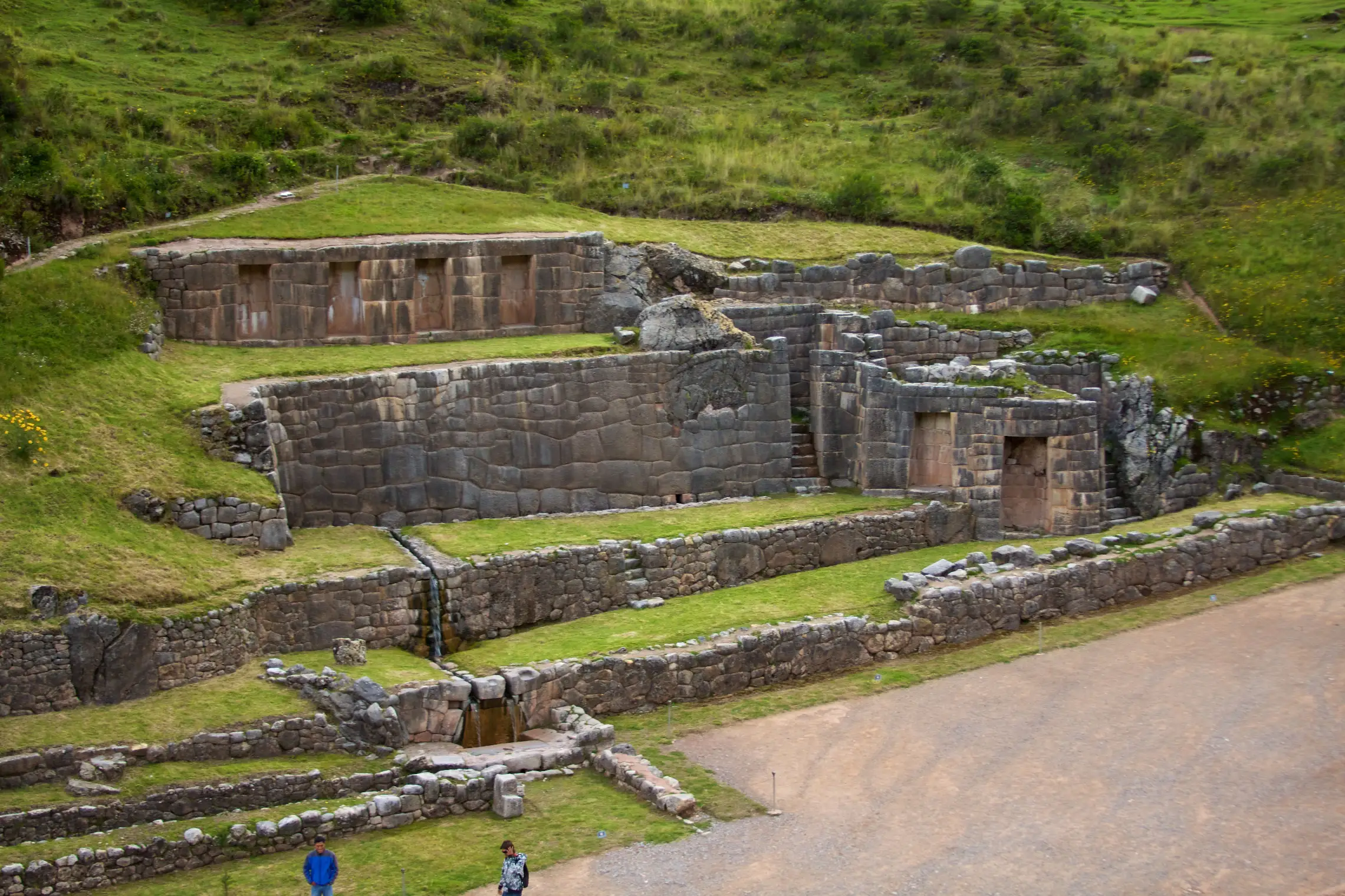
The site is thought to have been dedicated to water worship and served as a resting place for the Inca ruler. Photo by McKay Savage from London, under the UK, CC BY 2.0 < https://creativecommons.org/licenses/by/2.0 > license, via Wikimedia Commons .
At a Glance:
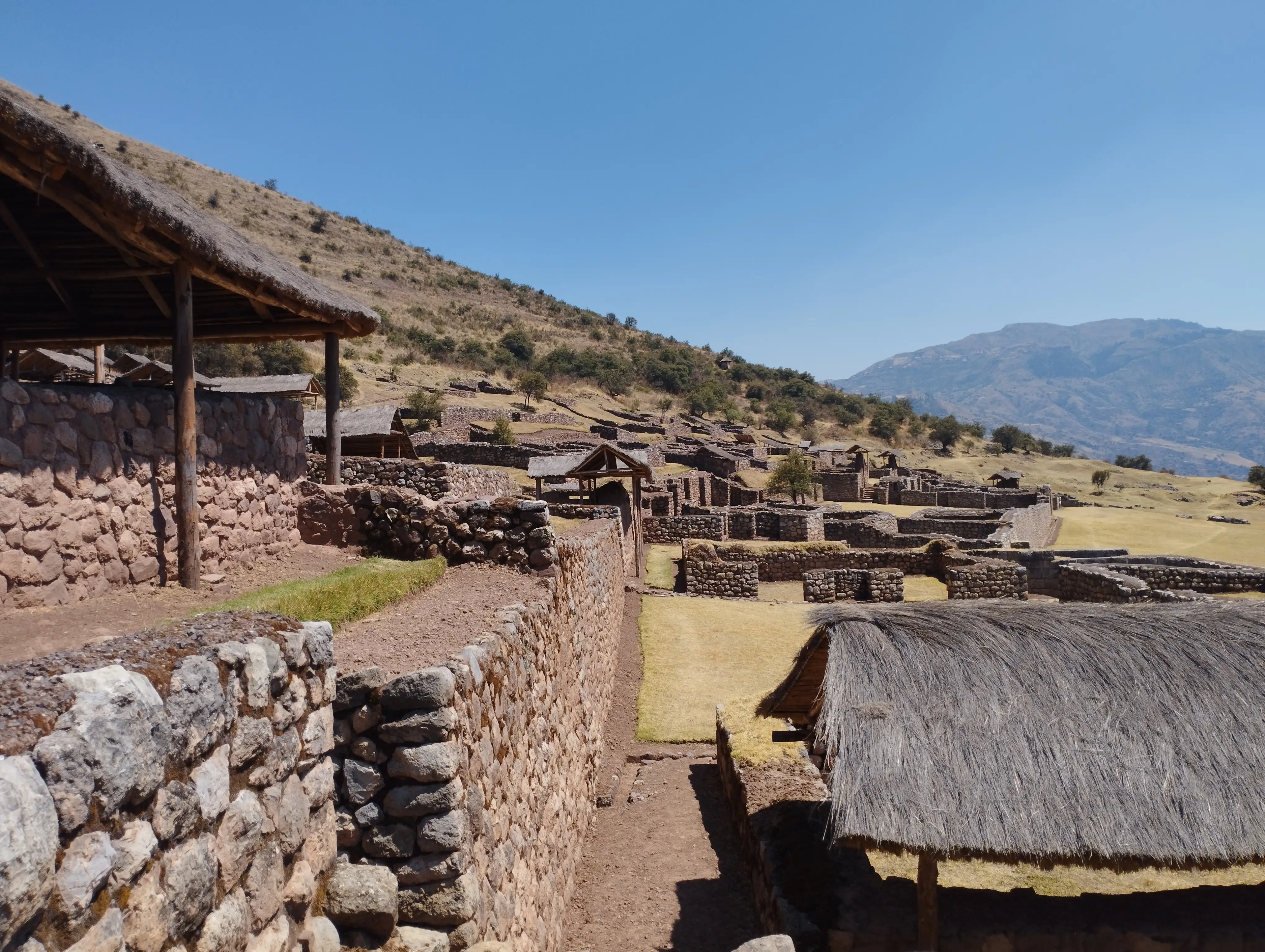
Pikillacta is a significant pre-Inca archaeological site that was built by the Wari civilization, which thrived between 550 and 1100 AD. It represents one of the most important remnants of this influential culture in the region.
Pikillacta, which means "place of fleas" in Quechua, is a sprawling complex that covers over 50 hectares (around 123 acres). It is characterized by its well-planned urban layout, featuring straight streets, large rectangular enclosures, and hundreds of buildings constructed with small stones and mud mortar. The site's organized design reflects the Wari's advanced understanding of urban planning and their ability to create large administrative and ceremonial centers.
The complex likely served as a major administrative hub, with facilities for storing agricultural produce, workshops, and residential areas for elite Wari officials. The site also includes a series of defensive walls, suggesting that security was an important consideration for its builders.
One of the most intriguing aspects of Pikillacta is its lack of elaborate decoration or monumental architecture, which contrasts with other contemporary sites in the Andes. This has led scholars to speculate about the site's specific function, with some suggesting it was primarily an administrative or military outpost rather than a religious or ceremonial center.
Today, Pikillacta is a popular tourist destination, offering visitors a unique opportunity to explore the remnants of the Wari civilization, which predated and influenced the later Inca Empire. The site is often included in tours of the Southern Valley of Cusco, alongside other attractions like Tipón and the Andahuaylillas Church, known as the "Sistine Chapel of the Andes." Pikillacta provides valuable insights into the pre-Inca cultures that shaped the history of the Andes and laid the foundations for the Inca Empire.
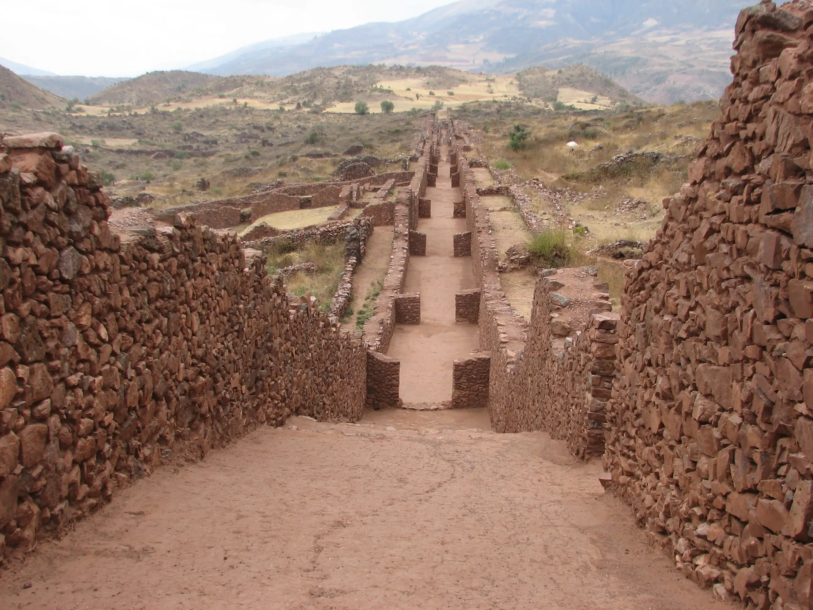
Pikillacta is a sprawling complex that covers over 50 hectares (around 123 acres). It is characterized by its well-planned urban layout, featuring straight streets, large rectangular enclosures, and hundreds of buildings constructed with small stones and mud mortar. Photo by I, AgainErick, under the CC BY-SA 3.0 < http://creativecommons.org/licenses/by-sa/3.0/ > license, via Wikimedia Commons .


Email: [email protected]
Sign up to receive our newsletter for great articles, stunning photos, and special deals.


.jpg)